How to use Navtor to order and correct ENCs ?
I have written quite a few articles on ECDIS. And I try to be as detailed as possible.
And all those articles on ECDIS are detailed enough.
These articles need to be detailed because ECDIS is comparatively a new thing and information is neither easily available nor easily understood.
But that is not the case with Navtor.
Navtor is one of the simplest software to use with any of the ECDIS.
Even if you have not used Navtor yet, I am sure that by the end of this article you would agree with me on its simplicity and ease of use.
Read on to believe me what I just said about Navtor.
What is Navtor?
Navtor defines itself as
a leading force in the provision of innovative e-Navigation solutions, and a total supplier of navigational products and services for the maritime sector. Every day we strive to make life easier for navigators, and safer, clearer and more efficient for shipowners, ship managers, and operators.
In simple words,
- Navtor supplies paper charts and paper publications
- Navtor is one of the ways for receiving e-corrections (NM) on board the ships
- Navtor supplies the ENCs for the ECDIS
- Navtor provides the corrections for the ENCs
If you have worked with Chartco, you might have noticed that the chartco does exactly the same.
Yes, Navtor can be considered to be the competitor of chartco.
But when it comes to the simplicity and ease of use, Hands down, Navtor has an edge over chartco.
When it comes to e-navigation, Navtor offers four products
As this article is about using Navtor to order, receive ENCs and update the ENCs on ECDIS, I would focus mainly on
- Nav Sync and Nav Stick; and
- Nav Box
- Nav-Tracker
Ordering ENCs
With Navtor, the ENCs for the ECDIS are ordered through Nav-Tracker software.
Each ship will have the Nav tracker installed on a ship’s computer. User ID and password will be provided for logging in to nav tracker.
But before we understand how to order ENCs on Navtor, we need to understand few things used in Nav Tracker.
Setting up the ship’s operational area
The operational area is the ship’s trading area. Once set up, the Navtor will only send the corrections for the ENCs in this area.
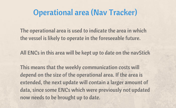
So it is important that the operational area is set up correctly.
When you click on the Nav tracker icon, the login screen will open.
![]()
Once logged in to the Nav tracker, click on the operational area.
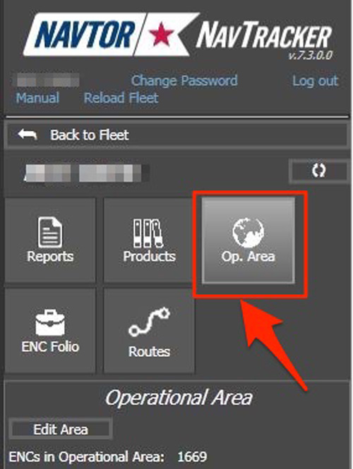
This will show the operational area set in the Nav-Tracker.
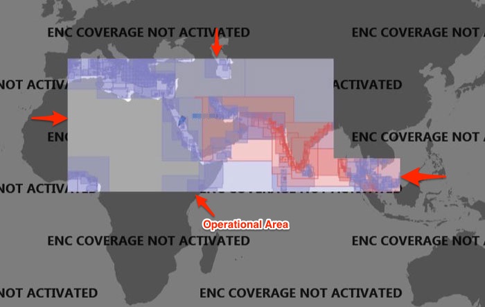
If we wish to extend the operational area to this, we can just click on the “Edit Area”, bring the mouse to the area that needs to be added and click on it.
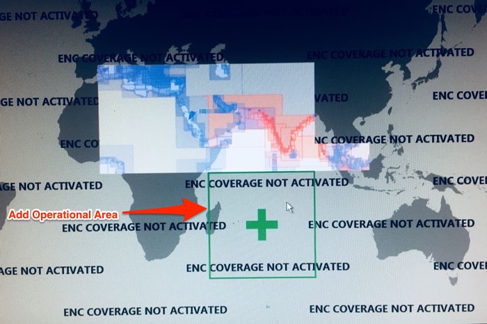
If you wish to select a smaller or larger area, you can zoom in or out on the screen.
Similarly to exclude an area from the operational area, we can take the pointer to the operational area and click when it shows a minus sign on the area. 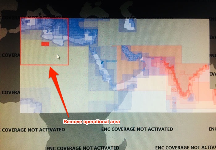
Once the operational area is set, just click on the Save and you have set the operational area of the ship in the Navtor.
You will receive all the updates for this area only.
Creating a route in Nav-Tracker
To order ENCs for a voyage, we first need to create a route in the Nav tracker.
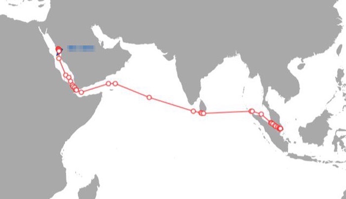
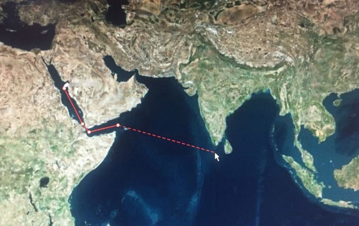
Let us say the vessel’s next voyage is from Yanbu to Singapore.
To know the ENCs required for this voyage and out of these ENCs the one not available or expiring, we need to have the voyage route in the Nav-Tracker.
This route can either be created manually in the Nav-Tracker or imported as ECDIS route file.
Importing the ECDIS route file
Store the route file (in this case Yanbu-Singapore route) from ECDIS to a USB flash drive.
Connect this flash drive to the computer with Nav-Tracker.
To import the route file, click on the routes option in the Nav-Tracker and then click “Import”
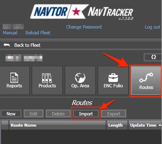
Choose the route file and click OK. This will import the route into the Nav-Tracker. A success message will be shown once the route is imported.
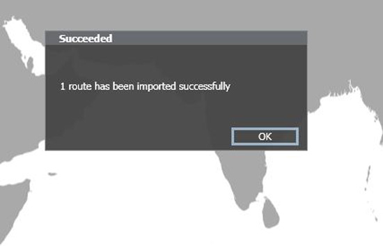
The imported route will be visible under the Route tab as well as on the map.
Creating a route Manually
You can also create the route manually in the Nav-Tracker but importing the route is much convenient.
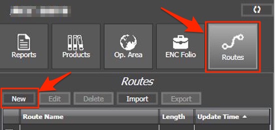
To create the route manually, go to “Routes” and click on “New”.
Now on the map in Nav-Tracker, take the mouse pointer to each of the waypoints and left click to add the waypoint into the route.
This is similar to making a route on the ECDIS.
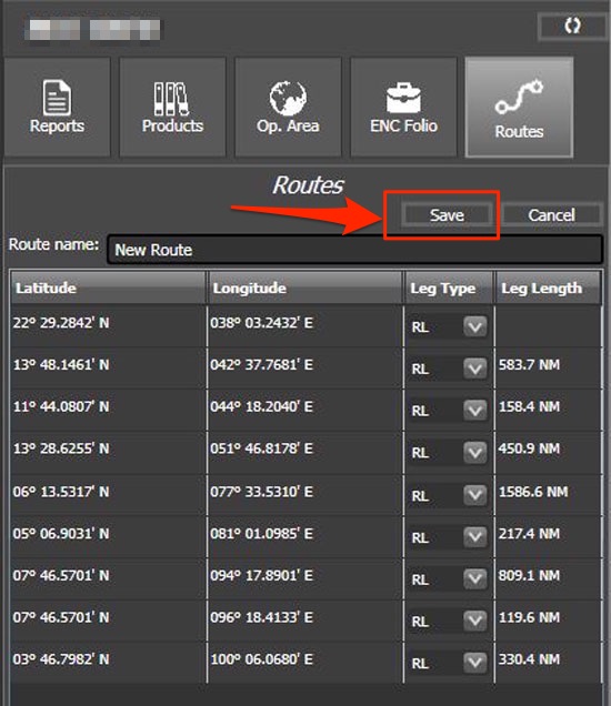
Once all the way points have been added, just click save to save the route.
PAYS and non-PAYS ENCs
Now before we move on to the process of ordering the ENCs on Navtor, we need to understand the concept of PAYS and non-PAYS ENCs.
PAYS ENCs
PAYS stands for Pay As You Sail. We do not need to order these ENCs.
As and when you sail on these ENCs, the cost is automatically billed to the ship operator.
Vessel’s position is tracked to know the ENCs actually used by the vessel.
All these ENCs (PAYS ENCs) for the set operational area are already there in the ECDIS. Navigators can use these ENCs for making the passage plan and other planning purposed without any cost to the operator.
Ship operator only needs to pay when the ship actually uses these ENCs for navigation.
Non-PAYS ENCs
There are few handful ENCs issuing countries that have not agreed to the PAYS system.
So these ENCs are not available for PAYS. These ENCs need to be ordered beforehand during the passage planning process.
How to order ENCs on Navtor
We are ready now to understand the process of ordering ENCs on Navtor.
As we understand now, we do not need to order PAYS ENCs. It is only Non-PAYS ENCs that are required to be ordered.
To order the required ENCs, go to “ENC Folio” option in the Nav-Tracker. From the list of the route, select the route you wish to order ENCs for.
Then click on the Order/renew licenses tab.
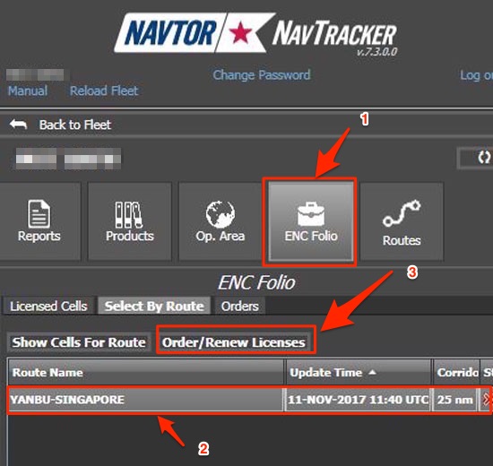
This will show a pop up to “choose Parameters”
- Corridor Width
- Default licensing period
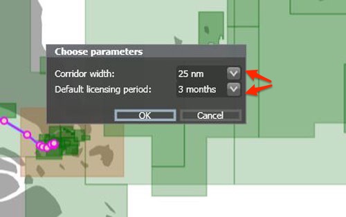
Corridor width is the distance from the planned course line for which we wish to have the ENCs.
Once we choose parameters and click OK, this will give us the list of required non-PAYS ENCs for the voyage with their status.
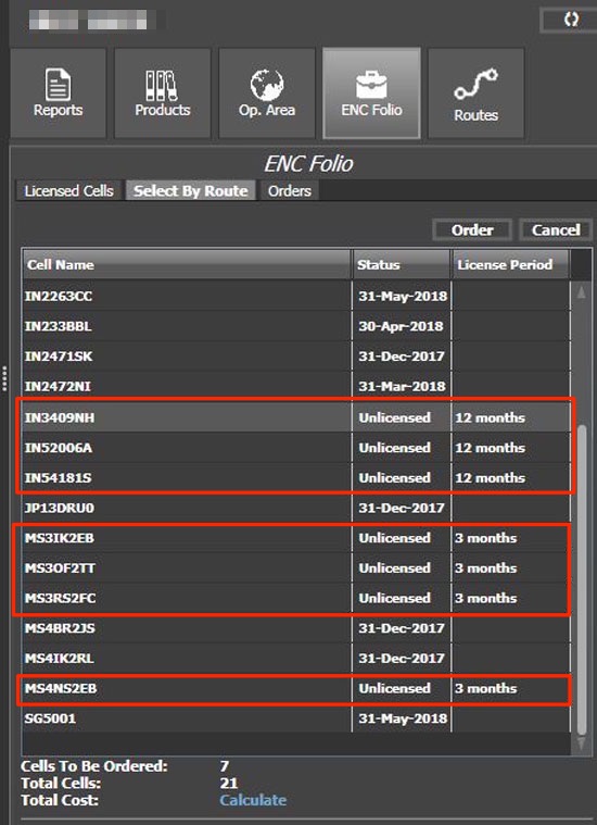
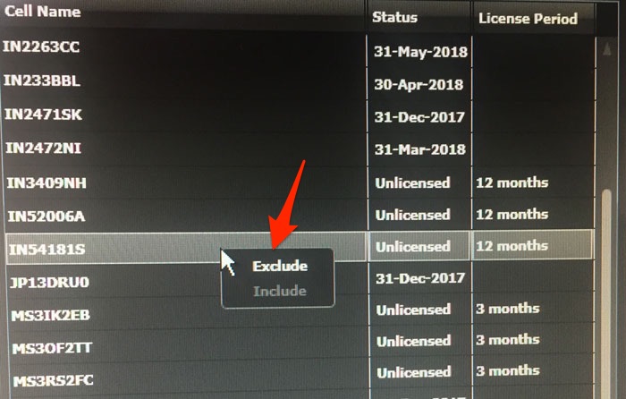
As we can see there are 7 ENCs that we need to order.
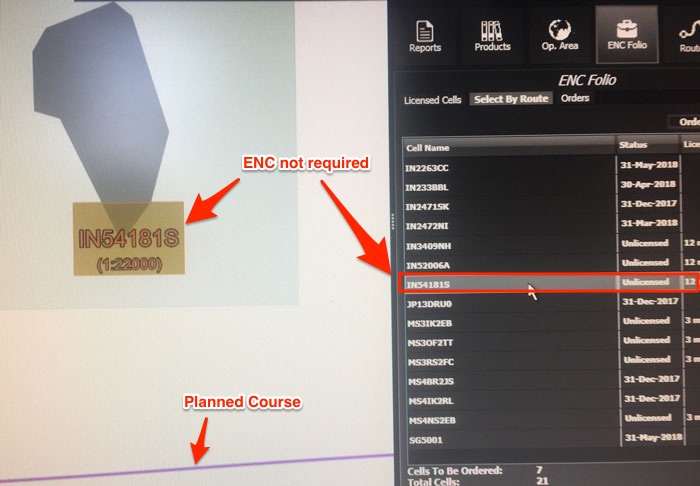
If you click on any of these ENCs, it will show the location of this ENC on the map.
Check each of these ENCs to ensure that these will absolutely be required.
For example, ENCs such as for this area may not be required for this voyage as this ENC is large scale ENC for an area which is not relevant for the voyage.
I want to remove this ENC from the order. To remove, just right click on the ENC and select “Exclude”.
Once you have finalized the list of ENCs to be ordered, Select these ENCs and click on “Order”.
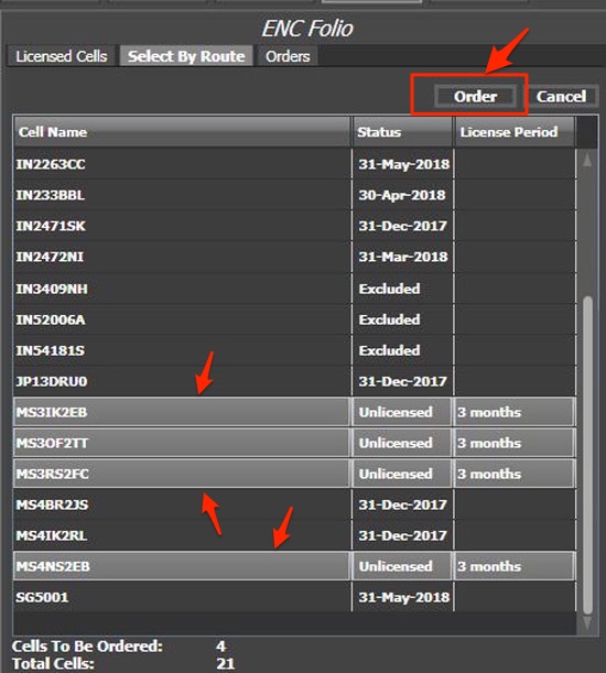
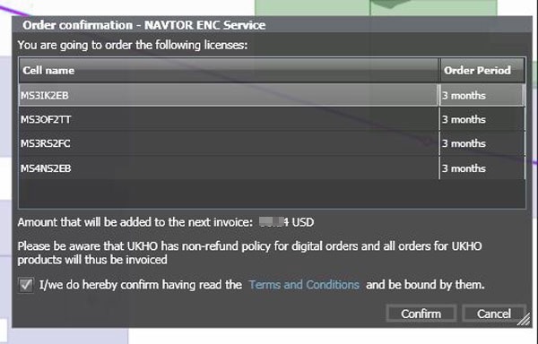
This will ask for the “order confirmation”. Click ‘Confirm” to create the order.
This order can be found under the “Orders” tab.
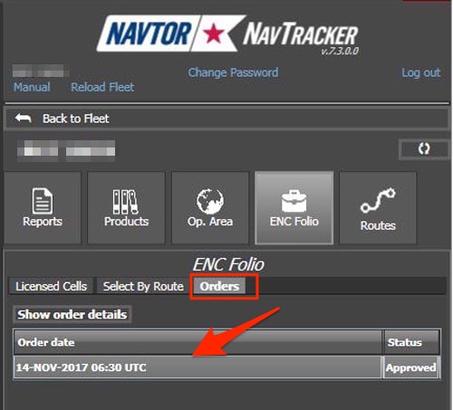
We have successfully created the orders for ENCs for the next voyage. The requested ENCs will be delivered in next update in the Navbox.
Importing and Correcting the ENCs
We have ordered the required ENCs for the voyage. But we need to get these and transfer to the ECDIS.
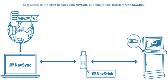
Navtor provides the ENCs and updates to the ENCs through
- NavBox
- NavSync and NavStick
NavBox
The Nav box is the software installed on the computer that contains all the ship’s ENC data and its updates. If this NavBox is connected with the ECDIS, all the updates will automatically be transferred to the ECDIS.
Navigators do not need to do anything with respect to updating the ENCs for weekly corrections.
If the ship’s NavBox is connected to the internet, the ordered ENCs will be available within one hour of ordering.
NavSync and NavStick
NavStick is the USB drive provided by Navtor which need to be updated every week for the weekly corrections and whenever new ENCs are ordered.
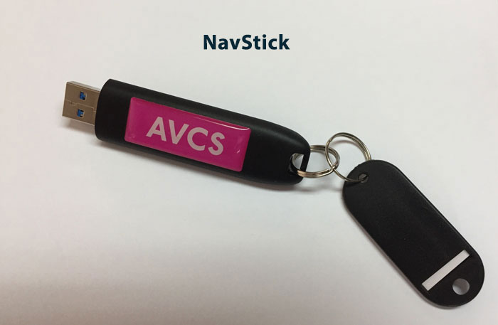
NavStick is updated (Synchronised) with a software called NavSync.
This is how NavSync and NavStick work together for updating ENCs.
The synchronization process is as simple as 1,2,3.
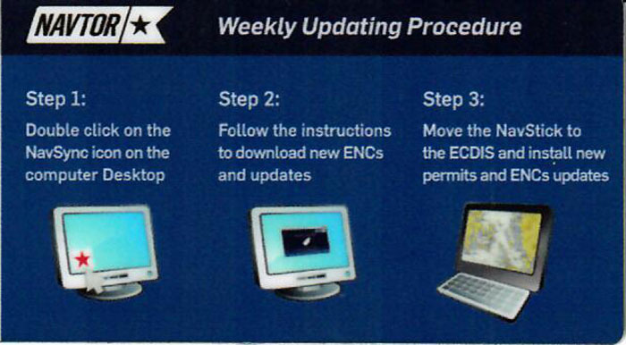
Yes, you heard that right. No need to update AIO separately and no need to update base cells. All will be collected automatically by updating the Nav Stick and then transferring it to ECDIS in one go.
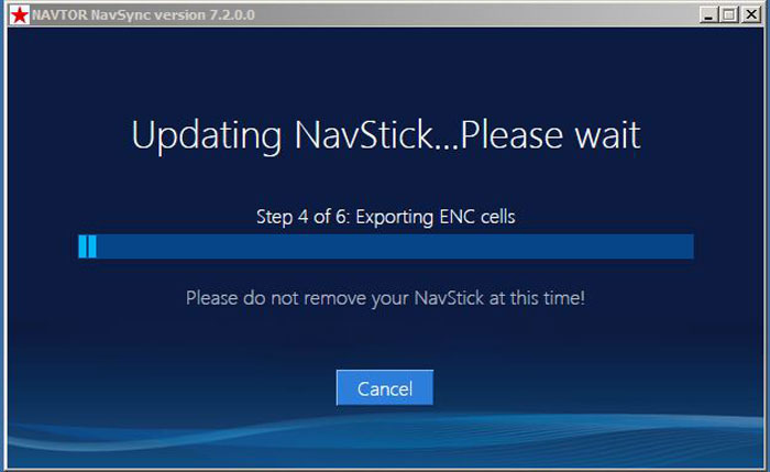
To Update the NavStick with latest updates, insert the NavStick to the computer with NavSync software.
Make sure that the internet connection is available on the NavSync computer.
Open NavSync and it will show if the new updates are available for the NavStick.
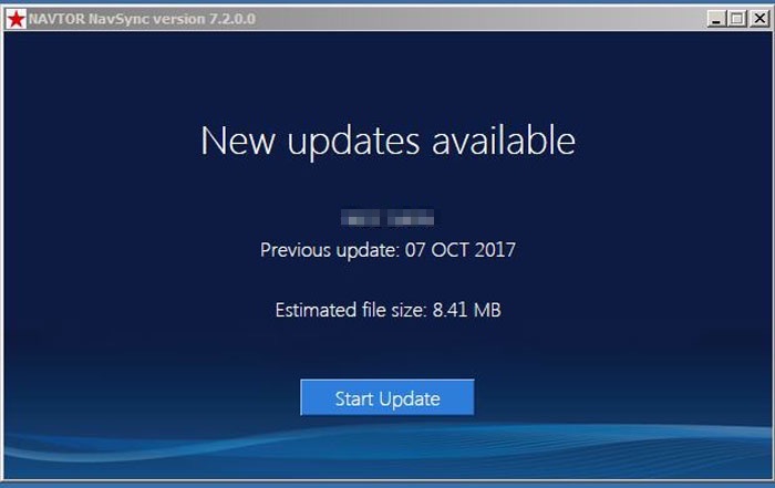
These updates will include permits for any new ENCs ordered. Once it shows new updates as available, click on “Start Update”.
It will start the updating of the Nav Stick.
Once the process of updating the Nav Stick is complete, it will show the message “ready to install new permits and ENCs.”
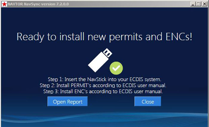
Now the Nav Stick is ready with new updates and can be used on the ECDIS to install these updates.
Each make of ECDIS have their own instructions to install updates and we need to follow these instructions.
In fact, I have covered that in of these blogs.
For JRC ECDIS, I have covered in this blog A step by step guide to ordering and correcting charts on ECDIS
For FURNO ECDIS, I have covered some extent of that in this blog How to Install ENCs on Furuno ECDIS- Step by Step Guide
Conclusion
Navtor is the most simple way to order the ENCs for the ECDIS and keep the ENCs updated.
Nav-Tracker software from Navtor handles the ordering part for the ENCs.
Nav Sync is the easiest way to keep the ENCs updated. Whenever new updates are available through Nav Sync or Nav Box, the ship will get a notification email.
Then we just need to connect the Nav Stick to the computer where Nav Sync is installed.
The Nav Stick will get updated and we can simply insert this Nav Stick to the ECDIS to update ENCs.
To update ENCs on the ECDIS we just need to follow the instructions of the ECDIS maker.
Welcome to the world of high tech shipping industry.
How to Handle Distress Messages Received on GMDSS
The strongest people make time to help others, even if they are struggling with their own personal demons.
This saying is so true for the navigators sailing on the high seas.
We ought to help people in distress.
In fact, even if someone does not wish to, they won’t have a choice.
IMO requires every ship to help any nearby ship in distress. Not doing so will be the serious violation of international rules.
GMDSS is the equipment on board that can let us know of any ship that may be in distress.
A ship in distress can transmit its distress message to the ships and shore station thousands of mile away.
When you receive a distress message from a ship that is 1000 NM away from its position, are you supposed to proceed for help?
Irrespective of how helping heart you may possess, proceeding to help in this case will be illogical.
So when must you proceed for help and when should you not?
What do you need to do on receiving a distress message on board?
Even if you are thousands of miles away from the ship in distress, is there any way you can be of some help?
Knowing these answers will not only help the ships in distress but also help us in avoiding the violation of international regulations on providing help to the ships in distress.
In this post, I will discuss the step by step procedures to follow on receiving a distress message on GMDSS equipments.
Let us start.
Receiving distress Alert on MF/HF
Now before I discuss the actions on receiving a distress message on MF/HF, it is important to emphasize on maintaining these equipments in good order.
The equipment should be able to receive and send distress messages when required. This guide can help in maintaining the MF/HF equipments in good order.
MF/HF Equipment tests: how to do it and actions in case test fails ?
Coming back to receiving a distress message on MF/HF equipment. This is what a distress message received on MF/HF would look like.
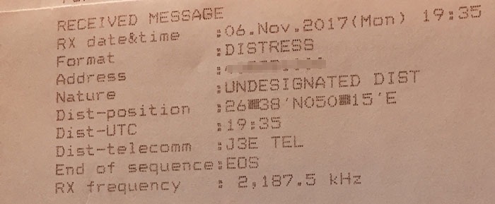
The first things OOW need to note in the distress message are
- The frequency on which this distress DSC alert is received, and
- the frequency on which the distress message will be transmitted.
In the sample distress alert above, this distress alert is received on 2187.5 KHz frequency.
Receiving distress message
We must understand that DSC is used to alert and tell the nearby ships and shore station that “I am in distress”.
The DSC alert may also have certain other information like the type of distress.
But the time permits, the vessel in distress needs to broadcast the more specific nature of its distress.
There are two ways this distress communication can go on.
- Through Radiotelephony (R/T)
- through NBDP
To be able to receive this distress communication, we must switch to either
- a common R/T frequency if the distress message is being broadcasted on R/T
- a common NBDP frequency if the distress message is being broadcasted on NBDP
This brings us to two questions.
How do we know if the ship in distress would broadcast its message on R/T or on NBDP?
And how do we know on which frequency she would broadcast the message?
Both the answers lie in the distress DSC alert received from the ship in distress.
The information about R/T or NBDP is contained in the “Distress-Telecomm “. In some equipments, this is denoted as “Telecommand”.
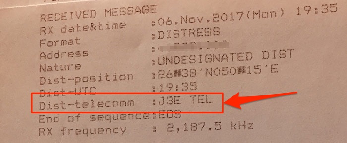
If the Distress-Telecomm is “J3E” or “F3E/G3E”, we need to switch to radiotelephony.
If the Distress-Telecomm is “F1B”, we need to switch to NBDP.
Now as in our sample DSC distress message, it is clear that we need to switch to radiotelephony and not NBDP but what frequency do we need to switch on?
Here is the frequency table which is posted near the GMDSS station.
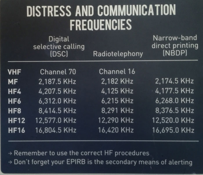
As the distress alert was received on the 2187.5 KHz frequency and as the distress message will be broadcasted on radiotelephony, we need to switch to the corresponding R/T frequency.
From the table, we can see that this frequency is 2182 KHz.
To switch to R/T on the MF/HF Station, check the present mode of the MF/HF equipment. On JRC, it is usually displayed on the screen.
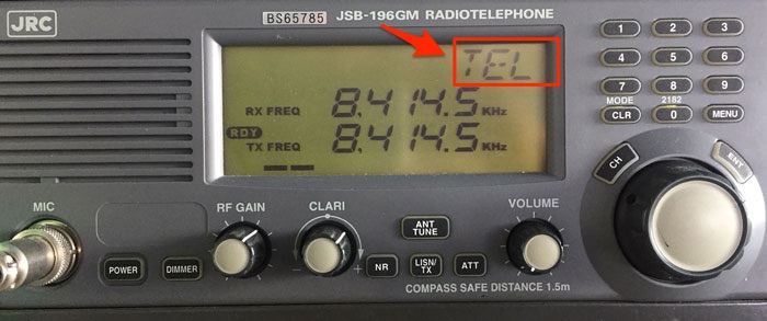
If it is not in the desired mode, change the mode by pressing the “Mode / CLR” button (on JRC).
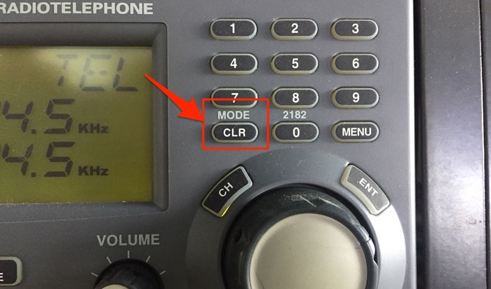
Once in the required mode, change the frequency by the number keys and press “ENT”.
Acknowledge distress alert or relay it
We have received the DSC distress alert and we have switched on to the corresponding frequency to listen to the distress message.
But the question remains. If we need to proceed to help the ship in distress or not?
We will get to that.
But first, we need to understand few actions that the ship receiving distress message need to and need not do.
Distress acknowledgment
When a distress message is sent by a ship in distress, it will continue to transmit the same message automatically in every 3.5 to 4.5 minutes.
This transmission will only stop when someone acknowledges the distress call.
The first lesson that every navigator need to understand is never to acknowledge a distress call from another ship.
Why?
Because it will stop the transmission of distress message from the ship in distress.
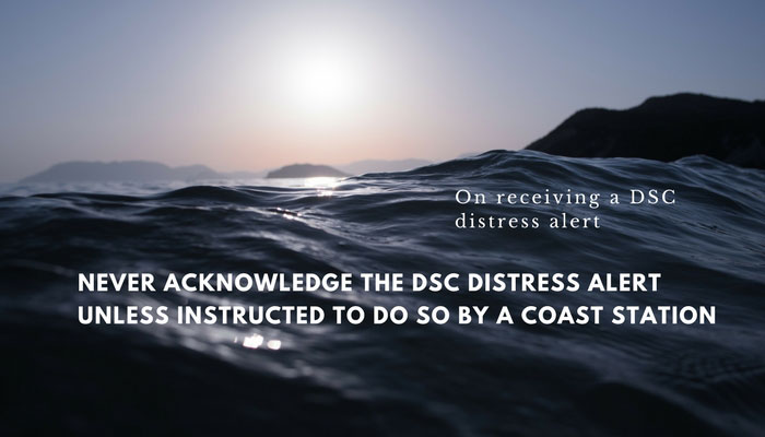
The distress message is only acknowledged by a coast station or by a ship when instructed by the coast station.
If coasts station asks to acknowledge the distress alert, only then we can do it. Let us discuss how to acknowledge a distress alert. I will show it on JRC MF/HF.
Press menu and go to option “Acknowledgement”.
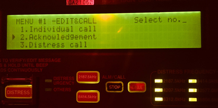
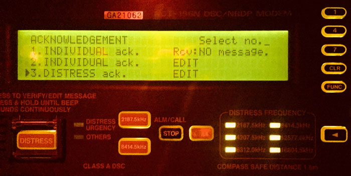
Press “Enter” and then choose “Distress acknowledgement”.
On the next screen, enter all the required data such as
- MMSI Number of the ship in distress (The distress ack will go to this id)
- Nature of distress
- Frequency on which to send the acknowledgement
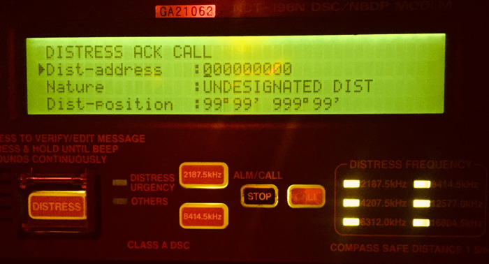
Once all data has been entered, just press the Call button to send the distress acknowledgement to the ship in distress.
Distress relay
We have to be clear on one thing. Apart from the ships in the immediate vicinity, If there is someone who has more resources to help a ship in distress, that would be the nearest coast station.
It is important that a coast station receives the distress alert and coordinates the distress traffic.
So if a distress alert is not received by the coast station, we need to transmit (relay) the distress alert to the nearest coast station.
Let us see how to relay a distress alert on JRC equipment.
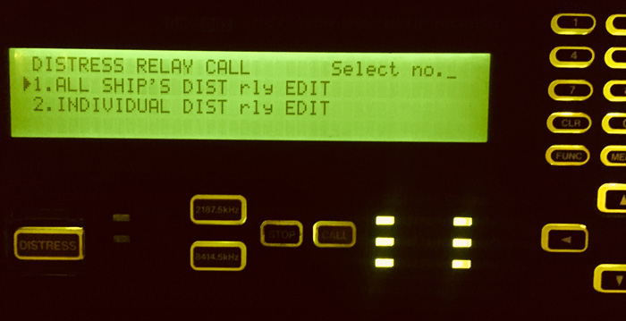
Go to Menu and then to the Option 4, which is “Distress Relay Call”.
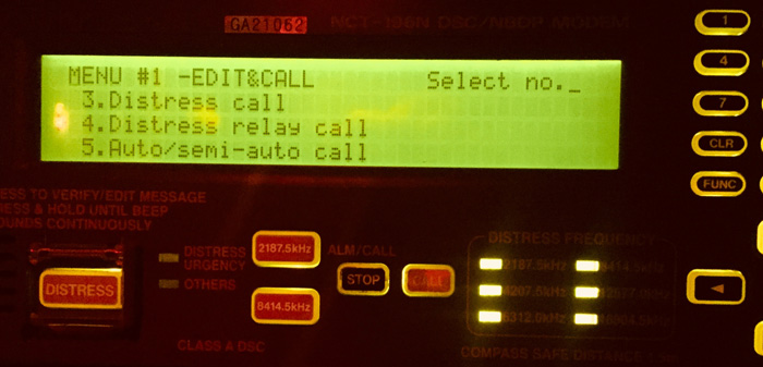
Under distress relay call option, choose “Individual DIST relay call”. In this option, we only send the distress relay to the coast station, the MMSI number of which we need to enter.
Now enter all the available details like
- Coast station MMSI Number (under address)
- MMSI number of the ship in distress (Under Distress address)
- Nature of distress
- All other information we have from the distress alert received.
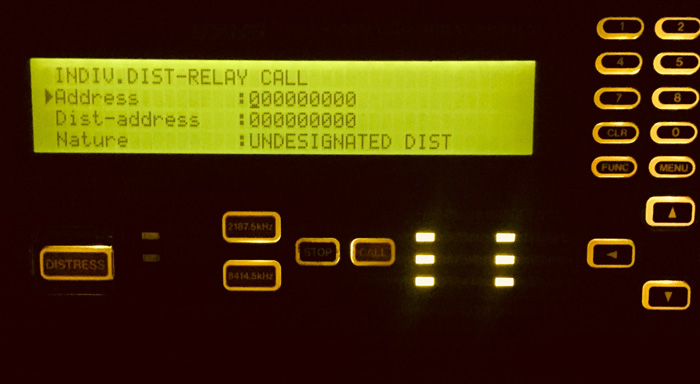
Finally, press “call” to send the distress relay to the coast station.
Action on receiving a DSC distress alert
Well, the laid down procedures for actions on receiving a DSC distress alert are simple.
This flow chart is supposed to be posted near the GMDSS station for quick reference.
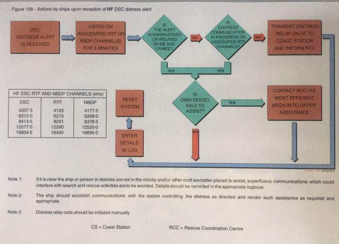
This flowchart gives the clear action which sometimes may not be clear on practical aspects.
Let us touch on each of these points.
Listen on the associated RTF or NBDP channel for 5 minutes
We have already discussed if we need to switch on RTF or NBDP.
We have also discussed which RTF or NBDP frequency we need to switch to.
The question is why we need to switch on to these frequencies and listen for 5 minutes?
What we are looking for is if any coast station has acknowledged the distress call or not.
But why 5 minutes?
The DSC equipment is designed to transmit the DSC distress alert every 3.5 minutes to 4.5 minutes unless acknowledged.
So when we wait for 5 minutes and if we receive the same DSC distress alert again, this would mean that coast station has not acknowledged the DSC distress alert.
Is the alert acknowledged or relayed by coast station
If we DO NOT receive the same DSC distress alert again within 5 minutes, it would mean that someone has acknowledged the distress alert.
In this case, we can be at peace that someone is helping the ship in distress.
If we receive the same distress message again within 5 minutes, it would mean that coast station has not acknowledged the distress alert.
Let us discuss the two scenarios one by one.
1. Distress alert acknowledged by the coast station
Let us consider that the distress alert has been acknowledged by the coast station.
In this case, if the vessel is far away and is in no position to provide help, we can move on.
If we are nearby and can provide help, we must contact the RCC by whatever means we can.
We just need to make the appropriate entry in the GMDSS log book about receiving this distress message.
A common question that we hear is, how far or near we should be to proceed to help a ship in distress?
Well, we will answer that question later in this blog.
2. Distress alert NOT acknowledged by the coast station
If the distress alert is not acknowledged by the coast station, it becomes our duty to ensure that coast station gets this distress alert.
But wait, maybe coast station did get this distress alert and is communicating with the ship in distress. They might just have not acknowledged the distress call.
We must know this by now by listening on the corresponding RT frequency or reading the communication on NBDP.
If any communication is going on with the ship in distress then we know that coast station has got the distress alert.
Again if we are in a position to help we get in touch with RCC to offer help. If not, we just make an entry in the GMDSS log book and continue our voyage.
Relaying the distress alert
I think I have said it for enormous times in this post.
We need to get the coast station into the picture. They are in the best position to coordinate the efforts to save a ship from distress.
So what if a DSC distress alert that you received is not acknowledged by the coast station. There is no distress communication on the associated RT or NBDP frequency either.
There can be many reasons why this can happen. Maybe you are closer to the ship in distress than the nearest coast station.
Whatever the reason for coast station not receiving or not responding to the distress alert, we have to get this alert delivered to the coast station.
We have to relay the distress message to the coast station.
To relay the distress, we need to have the MMSI number of the coast station nearest to the ship in distress.
Let us say we received a distress alert from a ship in the Arabian Sea. Let us find the detail of the coast station we can send the distress relay to.
Open the Digital list of Radio signals (or the ALRS book). Go to “Windows” option and check if the “Radio stations” option is selected.
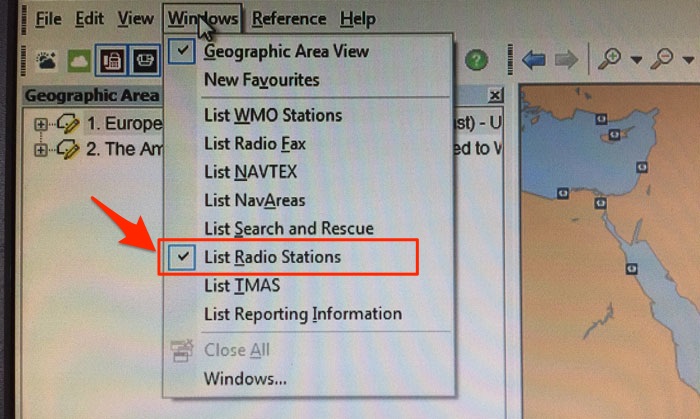
In the map, it will show the icons for the radio stations in operation.
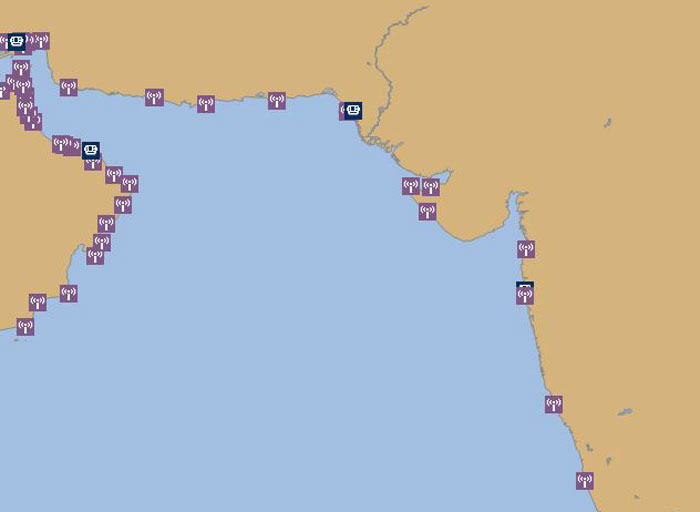
Let us say we choose Mumbai radio station for sending the distress relay to. Click on the icon of Mumbai radio station and it will show its information as a pop-up.
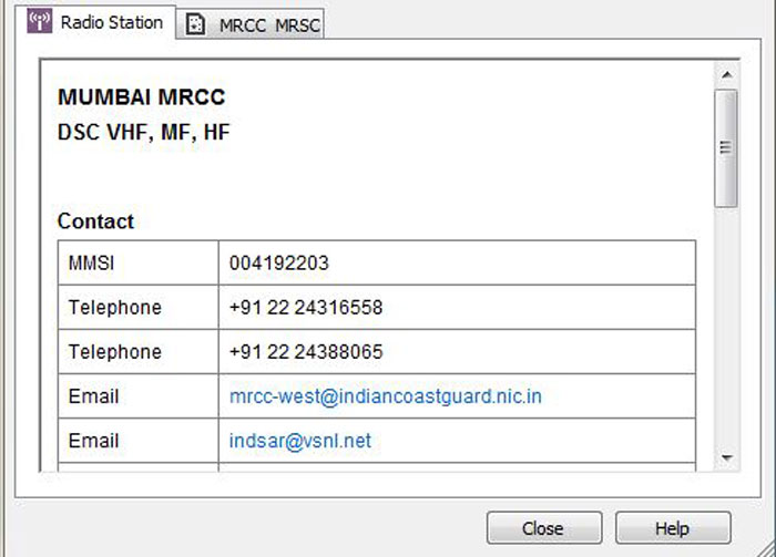
This has all the information including MMSI number.
Is own vessel able to assist
So far whatever actions we have discussed, I said that if the vessel is able to assist we need to get in touch with the RCC to offer assistance.
But how do we know if we are in the position to help?
A ship is in distress at a position about 100 nautical miles from our position. Shall we proceed to help?
Frankly, I do not have a definite answer to this.
Because it would depend upon so many factors.
If this distress alert is in mid-Atlantic ocean, we must offer assistance by getting in touch with the RCC.
If the weather, in this case, is not favourable, we then have to analyse the risk to our own ship.
If the ship in distress is in Malacca strait, 100NM is a lot of distance. Coast station will be in better position to help that ship.
In this case, we may continue to proceed on our voyage once coast station has acknowledged the distress call.
The master of the ship has to analyse and consider all the factors to decide if the ship is able to assist the ship in distress.
Conclusion
The ships are always on a tight schedule. Even one hour of delay is counted and scrutinized these days.
But even under so much of commercial pressure, we must not forget our duty to help the ships in distress.
In doing so, the first things we ought to ensure is that the “frequency table” and poster for “action on receiving a DSC distress alert” are posted near the GMDSS station.
While responding to the DSC distress alert, we must first ensure that a coast station has received the distress alert.
We can be sure of this if someone has acknowledged the distress alert and the alert is not repeating itself. Or if the coast station is communicating with the ship in distress on the corresponding frequency.
If they haven’t, we must relay the distress to the nearest coast station.
Finally, if the ship is able to assist we must inform the RCC about our ability to the help the ship in distress.
Here is All You Need to Know About Port State Control Inspections ?
 Even if I have to say it one hundred times, I would say it.
Port state control inspections are the lifeblood of the maritime trade.
It isn’t that the responsibility of the ship safety lies with the port state control.
The responsibility of the ship safety primarily lies with the ship staff, ship owners/managers, and flag states.
But what if the people primarily responsible for the ship safety fail to do their job well.
In fact, in the ideal world, there should not be any port state control. But that is only if we lived in the ideal world.
And in 1976, with the grounding of Amoco Cadiz, it proved that we do not live in ideal world.
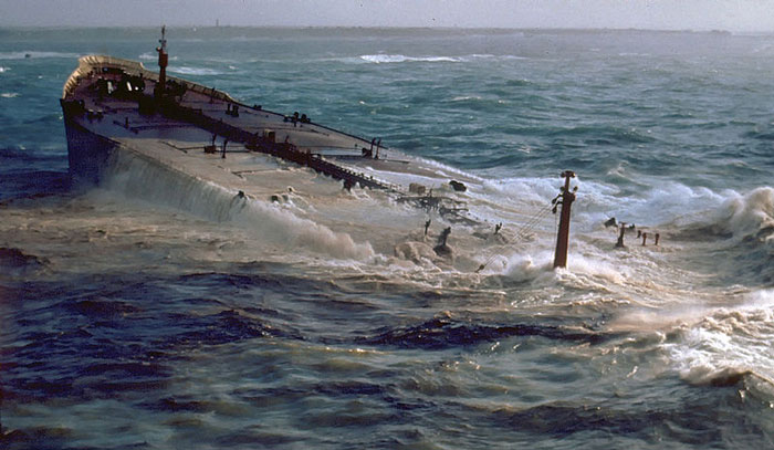 This is what happened to the tanker Amoco Cadiz.
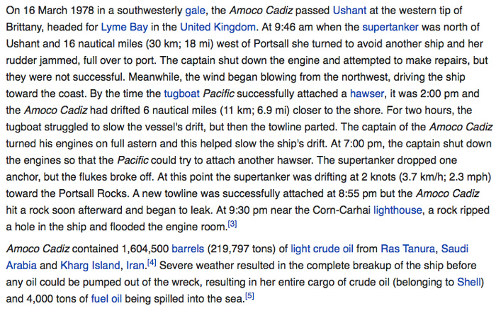 In a way, this incident led to having port state inspections of the foreign ships in the national ports.
The idea of having Port state control has traveled a long way since then.
In this post, I will discuss port state control inspections from seafarers point of view.
What is port state control
If you have been to sea for even for a couple of years, you would most likely know about port state control.
After all these inspections can easily eat up our shore leave, don’t they.
But the things is why are they doing these inspections.
Take for example this ship.
- Ship’s Flag is Singapore
- Ship’s Owner is based in the USA
- Ship’s Charterers are from Japan
- Ship’s Crew is from India and Philippines
Why would a port in Europe (say Rotterdam) want to inspect this ship when it arrives in that port? What do they get out of it?
Even though the ports may financially be covered for any ship related incidents but that would not be a reason enough to not prevent the accidents.
For example, you won’t accept someone to pay you after destroying your home furniture. You will be more interested in stopping someone to destroy your things.
So no country would want to welcome a sub-standard ship in their territory because of threat that these ships may possess.
But do the port state control have the legal powers to inspect a foreign ship. Yes, they do.
Various IMO conventions like SOLAS, Marpol, STCW defines the role of port state control in ensuring the implementation of these conventions.
Port State Control MoU
Before we discuss MOUs from the port state control point of view, let us understand what an MOU actually means.
As per google,
A memorandum of understanding (MOU or MoU) is a formal agreement between two or more parties. Companies and organizations can use MOUs to establish official partnerships. MOUs are not legally binding but they carry a degree of seriousness and mutual respect, stronger than a gentlemen’s agreement.
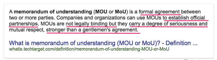 In simple words, an MOU is a formal agreement between two or more parties which brings mutual benefits for them.
With respect to port state controls, the meaning is no different.
The countries in an area (for example Europe) come together to work as a team for inspecting the ships calling their ports.
Port state control MOU, in other words, is the harmonized system for the different port state controls.
As per the MOU between different port states,
- They have common documented standards and procedures for the ship inspection
- they have a common database for the inspected ships
Port state control MOUs offered many benefits, to the port states as well as to the ships and shipping companies.
Among many other things, it offers cost saving.
How?
Let us take the example of Paris MOU which was the first MOU of the port state controls.
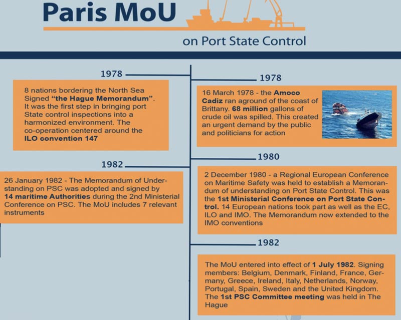 At this date, there are 27 countries that are the member of Paris MOU.
Belgium and Netherland are both the member countries of the Paris MOU.
A ship calls port of Antwerp (Belgium) and goes through the port state control inspection there. The inspection results were satisfactory.
Next, the ship is calling Rotterdam (Netherland). Having a common database under the Paris MOU means that PSC in Rotterdam would know that this ship has already been inspected.
This would not only save some costs in unnecessary inspection at Rotterdam but also save unnecessary burden on the ship staff.
A country can join any MoU that suits it. The MoU will accept the request from the country if the procedures of the PSC in that country are in line with the MoU procedures.
But it is most benefitting for the country to join their regional MoU because of common interest in the region.
For example, let us say a country in a far east joins the Paris MoU. A ship inspected in this country will not be inspected for the use of low sulphur fuel as per Annex VI special area.
When this ship arrives in Europe, ideally there should not any need to inspect this ship again as she has been inspected in a port under same MoU.
But the port in Europe would still want to inspect the ship for the marpol Annex VI compliance.
In fact, this is one of the few reasons as to Why we have regional MoUs and not one combine under IMO?
The port state control MOUs are established as per the region to have regional co-operation between different PSCs.
At present, there are nine PSC MOUs. 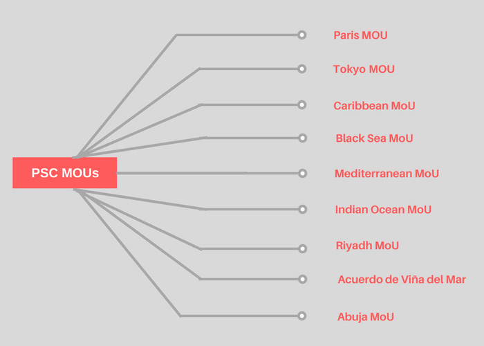 Targeting the ships
One thing that we all understand is that we are all short of resources. And port state controls are no different.
No port state control can inspect all the ships calling their ports.
Having regional corporation between PSCs through MOU reduces some burden and need to inspect all the ships.
So if a ship has been recently inspected at a country that is part of the MOU, there would be no need to inspect that ship again.
But still, the number of ships that need to be inspected is no less considering in some ports there are hundreds of ships calling each day.
Consider this for a port.
Number of ships called in on a particular day = 30
Number of ships that have not been inspected by any MOU country = 23
Number of PSC inspectors available = 12
Number of ships that can be inspected on that day = 12
So out of 23 ships that need to be inspected, only 12 can be inspected on that day.
But which 12 ships from these 23 ships should the PSC inspect?
That is where calculating the ship’s risk profile helps.
Each ship is assigned a risk profile factor based upon the
- type of ship
- age of the ship
- Flag of the ship
- Classification society of the ship
- Performance of the Ship’s ISM company
- History of the ship
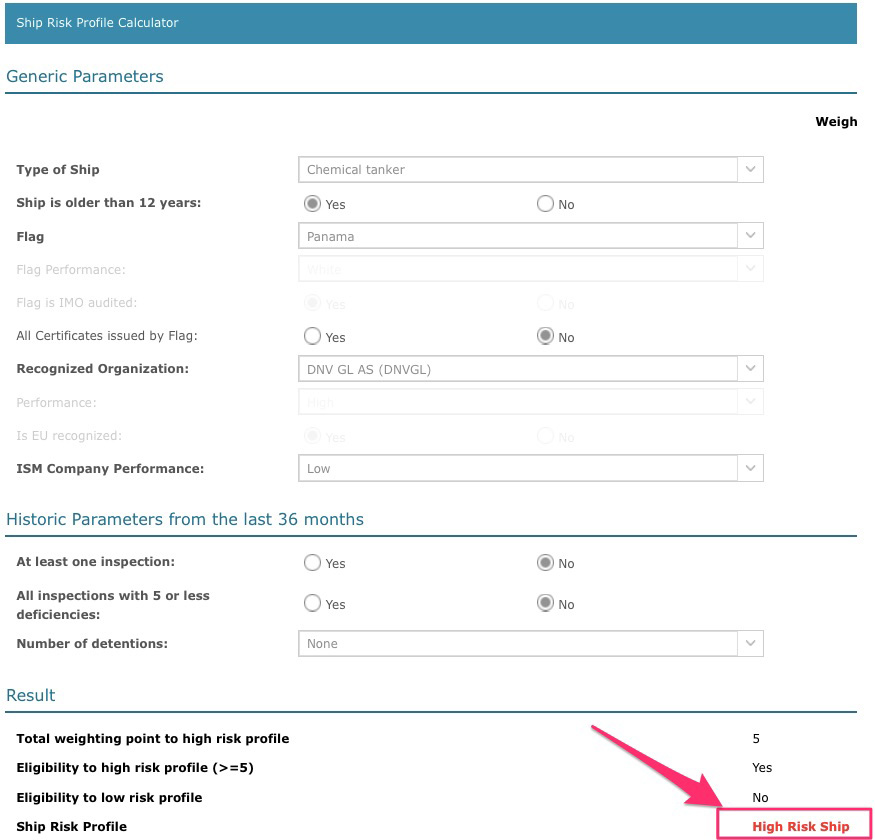
So in the example we discussed, out of 23 ships, 12 ships with higher risk profiles will be inspected.
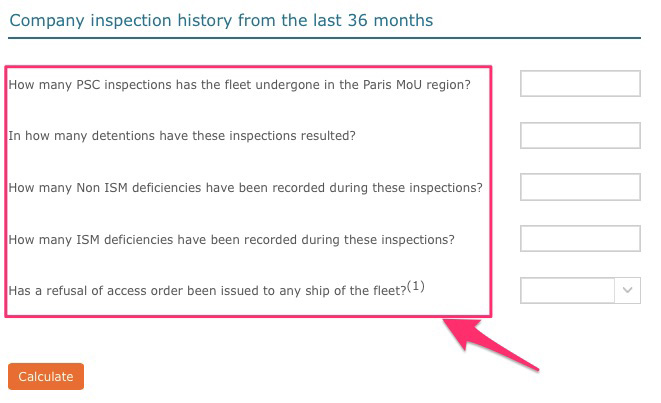
Not only the ship’s performance acts as a factor for ship risk profile but it also takes into account the performance of the company.
Type of PSC inspections
When a PSC inspector boards the vessel, he would conduct one of the four types of PSC inspections.
These inspection types are
- Initial Inspection
- More detailed inspection
- expanded inspection
- Concentrated inspection campaign
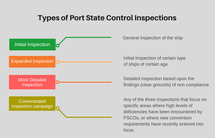
Initial Inspection
An initial inspection is a general inspection of certificates and a round on deck, engine room, galley and other common areas.
Expanded inspection
Expanded inspection is the initial inspection with a wider scope.
It is generally carried out on ships that fall under higher risk category compared to other ships.
For example, for Paris MOU, the expanded inspection is done for ships
- Oil tankers over 15 years old and over 3,000GT
- Gas and chemical tankers over ten years old
- Bulk Carriers over 12 years old
- Passenger ships over 15 years old
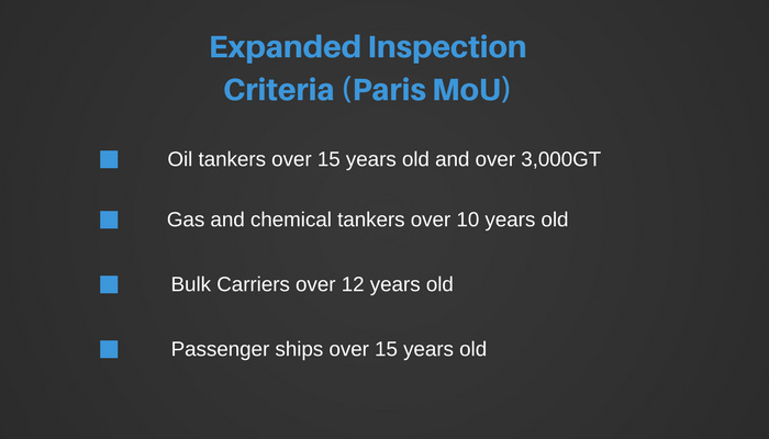 As expanded inspections would require more time compared to the initial inspections, Paris MOU requires the ships to report to the PSC before arrival if their ship falls under high-risk category.
More detailed inspection
During an initial inspection or expanded inspection of the ship, the PSC inspector may have certain findings (Clear grounds) that point out to the non-compliance with certain regulations.
In this case, the PSC inspector would change the scope of the inspection to more detailed inspection.
Few examples of clear ground could be
- A missing mandatory certificate
- Oil record book entries that do not add up and points towards a possible Marpol violation. PSC inspector will focus on checking Marpol elements during the more detailed inspection.
- Crew members not aware of their duties during fire emergencies and abandon ship. In this case, PSC inspector would concentrate more on emergency preparedness of the ship during a more detailed inspection.
- Multiple violations of the rest hours. In this case, PSC inspector would focus on MLC related elements during the more detailed inspection.
Concentrated inspection campaign
Port state control MoUs runs campaigns to concentrate their inspection on any one area of ship operation.
These areas are chosen in the MoU meetings.
For example, Paris MoU and Tokyo MoU have started concentrated inspection campaign on navigation safety which will be carried out from September 2017 to November 2017.
During this campaign period, PSC inspector during usual ship inspections will check certain areas related to the campaign.
The information on areas to be checked are developed as a questionnaire. PSC inspector follows this questionnaire and he will answer each question based on the findings of the ship.
Here is the questionnaire for the navigation concentrated inspection campaign by Paris MoU.
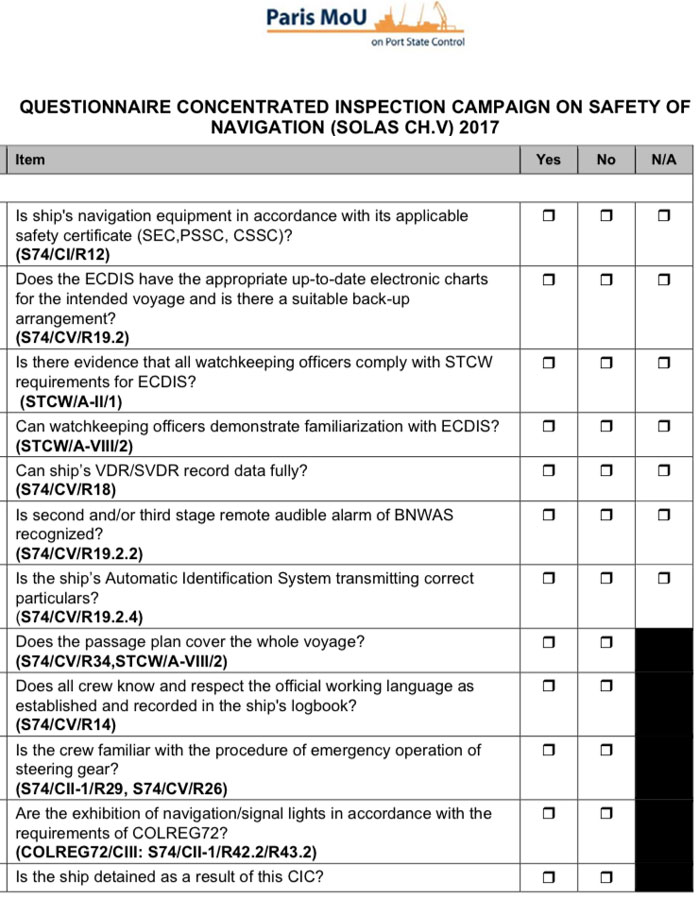
At the end of the campaign, port state control MoU posts the detailed findings of the campaign.
At the beginning of the inspection, PSC inspector will let the master know about the type of inspection he would be conducting.

Even during an initial inspection, if the PSC inspector has the reasons for more detailed inspection, he will let the master know that the scope of inspection has now changed and now the inspection is “More detailed inspection”.
PSC inspection results
Irrespective of the type of PSC inspection carried out on board, either it will result in no deficiencies or some deficiencies.
If there are no deficiencies, we just file the PSC inspection report and inform the company about the PSC inspection.
If there are deficiencies, these deficiencies can fall under one of these three categories.
- Detainable deficiency
- Deficiency that needs to be corrected before departure
- Deficiency that needs to be corrected within a time range
Detainable deficiency
If the ship is detained because of one or more observed deficiencies, the PSC inspector will provide a “notice of detention” to the master.
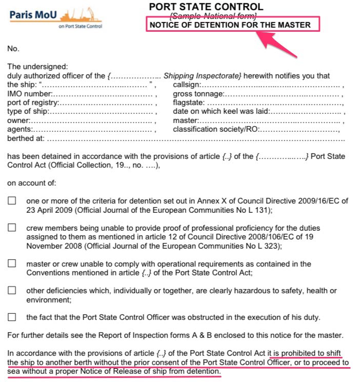
In this case, the Master of the ship cannot move the ship from the berth without the permission of port state control.
Once the detainable deficiencies are rectified, the master needs to contact the port state control officer for verification of the corrective actions.
The port state control officer will board the vessel and conduct the verification of the corrective action taken and rectification of deficiencies.
When satisfied, the PSC will issue the “notification of release” of the ship.
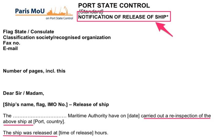
Master of the ship must ensure that a copy of the notice of release of the ship is on board before the vessel leaves the port.
Deficiency that needs to be corrected before departure
There can be a deficiency that PSC wants the ship to correct before departure. The action code for such deficiency is “Code 17”.
Upon receiving such deficiency, the master of the ship must clarify with the PSC inspector if re-verification this port will be required to close this deficiency.
For most of the port state controls, the statement of the master that the deficiency has been rectified is enough.
For example, PSCs under Paris MoU does not require the PSC inspector to verify the rectification of such deficiency.
Even then, it is a good practice to send an email to the Port state control informing them of the fact that the identified deficiency has been rectified.
A copy of this email can be attached to the PSC report.
Deficiency that needs to be corrected within a time range
Apart from detainable deficiency and Code 17 deficiencies, PSC inspector may give deficiencies with action code such as
- To be corrected at next port (Code 15)
- To be rectified within 14 days (Code 16)
In this case, if the next port is in same MoU, a request of re-inspection must be sent by the master to the port state control intimating that deficiency has been rectified.
If it is in different MoU, then an email should be sent to the PSC confirming that the deficiency has been rectified.
Again, for code 16 deficiencies too, the master must send an email to the PSC within 14 days confirming that deficiency has been rectified.
Conclusion
The whole idea of the port state control is to give no operating space to the sub-standard ships.
The only way to eradicate the sub-standard ships is to inspect the ships. But no port state can have so many resources to inspect each ship that call their ports.
Having regional cooperation between different port states (PSC MoUs) eliminated the need for inspecting each ship.
Port state controls under the same MoU shared the ship inspections results with a common database.
Assigning a risk factor to each ship set the priority for inspection of a ship. With this, the ships with higher risk profile were given a priority for inspection over the ships with lower risk profile.
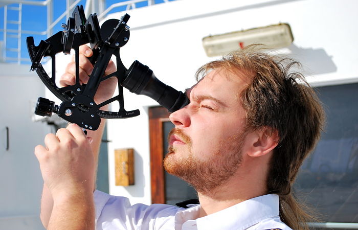
How a Marine Sextant Helps in Getting Ship Position ?
 In the age of Google maps, GPS and AIS, there is something in the wheelhouse that looks so outdated.
I am talking about sextant and getting the position of the ship by sextant.
Now before you yawn and find some more sexy navigation topic to jam on, hear me out.
Sextant has something unique that all the advanced technologies cannot match.
It can give you your accurate position without relying on any electronic aid or satellite.
That is the reason sextant has been there and as far as we can tell, it always will be.
But there is also a drawback. To get a position from the sextant requires some calculations and expertise in handling the sextant.
Also, the position is not instant read out like in modern equipments.
But more you use the sextant, more these drawbacks are marginalized.
Now you may know all the calculations of the sextant. You may know about long by chron, Mer-pass and all other calculations to get the ship’s position.
But if you don’t know how the hell an equipment like sextant can get us our position, you are missing everything.
And anyone who wants to learn just that, they need to start with something very basic. Position lines.
Position Lines
I am going to assume that you know nothing about “position lines”.
That is totally OK. I will spell it out for you.
A position line is a line on which lies a point where ship’s position will be.
Let us say you take a bearing of a lighthouse and the bearing is 310 Degrees. Now draw a line with bearing 310 meeting the island. In other words, draw a line in a direction of 130 degrees from the lighthouse.
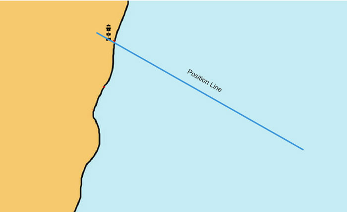 This line is a position line as your position ought to be somewhere on this line.
But you see, if I randomly choose 5 points on this line, one of which is your position, Can you tell be which one is your position?
No, right?
For this reason, we need two position lines separated by some angle to know our position. The point where two position lines would intersect will be your position.
So in our case, let us say we take the bearing of another lighthouse and it is 240 Degrees. We draw this position line.
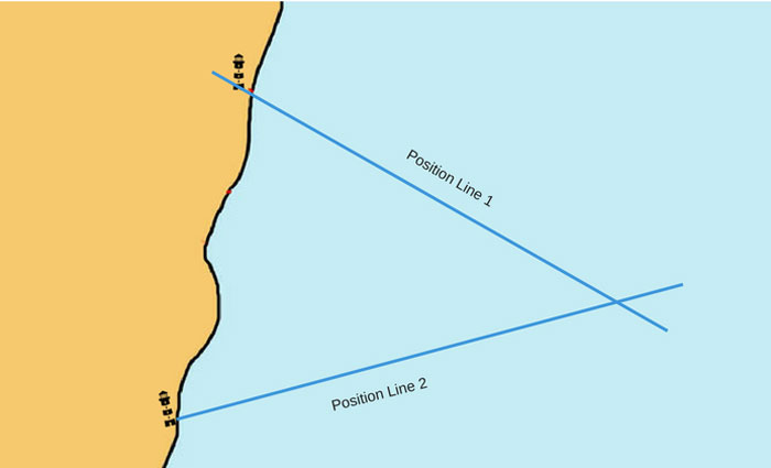 The position where these two positions line would intersect is your position.
On board ships, whichever way you get the ship’s position, it always involves at least two position lines.
GPS gives us two position lines separated by 90 degrees angle. These position lines are
- Latitude
- Longitude
Position by celestial observations
The principles of plotting position by celestial observations is no different than usual terrestrial observations.
In celestial observations too, we need at least two position lines to get the ship’s position.
But to get a celestial position lines is not as simple as getting terrestrial position lines.
Now why I say it is different ?
When we take a bearing of an object (like a lighthouse), we have the lighthouse on the chart. We just plot the position line or position circle from that object.
But if we get the distance or bearing of the celestial object (like sun), we have two issues
- We do not have that celestial object on our chart from where we can just draw the position line, and
- The object is too far away
So what do we do? We have to do two things
- We have to shift our position to space (Zenith) so that we can measure our distance from the celestial object (Zenith distance).
- We have to bring the celestial object (for example sun) to the earth (Geographical position of the object) so that we can plot the measured distance on the earth’s surface.
Don’t worry. We don’t need to rent a rocket to go to space to measure that distance.
But I mentioned here few words.
- Zenith
- Zenith Distance
- Geographical position of the object
Let us see what are these.
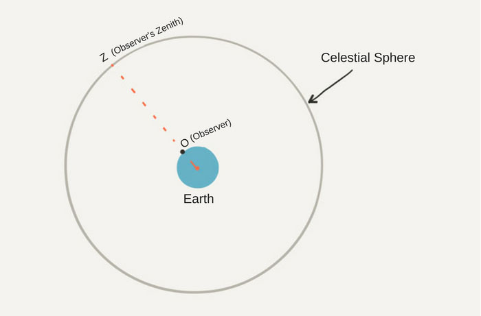
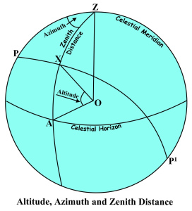
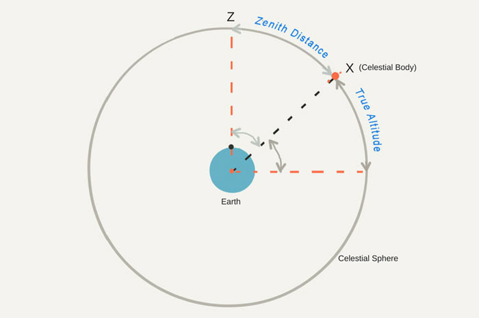
Zenith
Zenith is the point on the celestial sphere directly above the observer. That is, it is the point that meets the celestial sphere when a line is drawn from the center of the earth through the observer.
Zenith Distance
In simple words, zenith distance is the distance between Zenith and center of the celestial body.
Geographical position of the celestial body
The geographical position of the celestial object is the position on earth’s surface that is obtained by joining a line from that object to the center of the earth.
The geographical position of any celestial object is given in term of GHA and Declination.
If we have to compare this with Latitude and longitude then
- Declination is the latitude of the celestial body and
- GHA is the longitude of the celestial body
To understand these terms, let us take the earth surrounded by the celestial sphere.
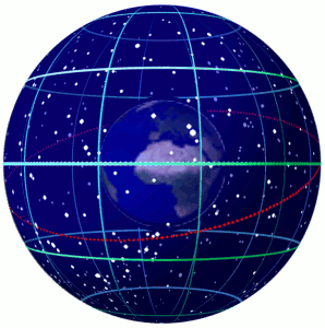
The celestial sphere is the imaginary sphere of infinite radius with its center at the center of the earth.
Let us say our position is at O.
Now join the center of the earth to our position and extend it to meet the celestial sphere. The point where it meets the celestial sphere is our (observer’s) zenith. We denote it by Letter “Z”.
 Now let us assume the celestial body (we will take the example of Sun) is at position “X”
The distance of arc ZX is the zenith distance. It is measured as the angle at the center of the earth.
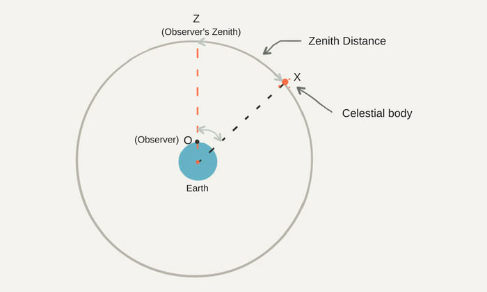 For example if the zenith distance was 40 Degrees, on the surface of the earth this would mean a distance of 2400 miles. One degree at the center of earth approximately equals to 60 Miles.
If we need to draw this position circle, we need to draw this from the geographical position of the celestial body.
So if we draw a circle of 2400 Miles (40 deg x 60 miles), from sun’s geographical position, our position will be somewhere on that circle.
Ideally, we would have got the position circle with this distance. Zenith distance should be all that we need to get one position line.
If we compare it to the terrestrial position lines, zenith distance can be compared to the range.
But only problem is it would be difficult to draw this big position circle on the chart.
Not only that. This big position circle would cover half the world. So it would be like saying that the ship’s position is anywhere on this earth.
So even though we have one position circle, it is of no use to us as this cannot be plotted.
Then how do we make use of it to get ship’s position?
Well, first we can shorten this position circle and concentrate only on that portion of it which is near to our DR position.
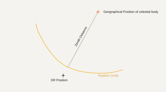 This part of the position circle can considered to be a straight line and thus a position line.
This is because for a circle of as large radius as hundreds of miles, a small arc will look like a straight line.
The direction of this straight line near the DR position of the ship can be taken as the direction of the Position line.
But to get the direction of this Position line, we still need to draw the arc of 2400 miles and measure the angle of the position line. Isn’t it? Which we earlier agreed is difficult.
We can find the direction of the position line in a different way.
We know that tangent to a circle is at 90 degrees to the radius of the circle.
So if we take the azimuth of the celestial body, it will pass through the radius of this position circle. And the a line 90 degrees to the azimuth will be the position line we need.
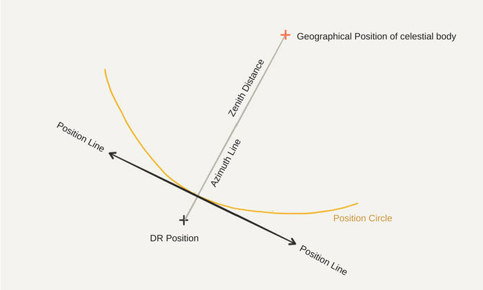 So we calculate the azimuth of the celestial body and our position line will be 90 degrees from the azimuth.
Let us say, we calculate the azimuth of the sun and found it to be 060 Degrees. The position line will be 150 deg – 330 Deg.
Now there are two questions that should be troubling our mind.
We said that we will have
- Distance from our position to the geographical position of the celestial body, and
- Azimuth of the celestial body
If we compare this with terrestrial objects, this is kind of saying that we have range and bearing of a lighthouse.
If this is so then,
Wouldn’t the intersection of azimuth and zenith distance of the celestial body be the ship’s position?
Well, actually the answer is that it certainly should be the ship’s position. But provided all the data is correct.
If there is slightest of the difference between the actual azimuth and the azimuth we calculate, the position will be offset by miles.
For example with the 1-degree error in azimuth for position circle of 2400 miles, the position will be offset by approx 40 miles. I leave the math up to you.
There is another reason for this.
For calculating the azimuth of the celestial body, we have used the observed position of the ship. This is not our actual position (which of course we intend to calculate with all this exercise).
Which means that the azimuth is for observed position and not at the ship’s actual position.
Where does sextant fit in all this?
If we need to get our basics of sight calculation right, there is one final question we must answer.
Where does sextant fit in all this?
As I explained little while earlier that to get a celestial position line, we need two values
- Zenith distance of the celestial body
- Azimuth of the celestial body
Getting the azimuth of the celestial body is a simple calculation. We calculate the azimuth with A,B,C tables (or by solving PZX triangle) all the time for compass error calculations.
 But how can we get the zenith distance of the celestial body ?
Well, there is a relation between zenith distance and the altitude of the celestial body.
The sum of altitude and zenith distance is always 90 degrees.
 So if we know the altitude of the celestial body, we would know the zenith distance.
The sextant measures the altitude and that is where it fits in the sight calculation process.
There are few corrections that need to be applied to the altitude measured with the sextant to get the true altitude of the body.
So in all the sight calculations, all we are aiming for is
- To get a position line which we can calculate by calculating the azimuth of the celestial body
- To get the position from where we need to draw this position line. This we get by calculating the zenith distance of the celestial body
Conclusion
To fix the position of ship by celestial sight requires two things
- A position line
- A position through which to draw the position line
We get the position line by calculating the azimuth of the celestial body. The position line is 90 degrees from the azimuth.
We also need the position from which to draw this position line. This is calculated by using the Zenith distance of the body, which we can get from the altitude of the body.
The intersection of two such position lines brought to same time will give the ship’s position.
Whole this process of may look boring but more you practice it, more interesting it becomes.
And when you have mastered the art of fixing ship’s position by sextant, you can proudly own this quote.
All I need a ship and a star to steer her by.
How to ensure Compliance with SOx and NOx requirements
Air pollution is a real thing. And the world can already see what damages it is causing.
Air pollution has caused a drastic increase in the number of Asthma patients.
Air pollution has caused acid rain which damages the ecology.

And air pollution is the main contributor to global warming.
So air pollution is a real thing and we need to act today.

That is what IMO must have said to itself in the year 1997 when it adopted Annex VI to the Marpol convention.
Air pollution, Global warming, acid rain, ozone depletion. No matter how big words these may seem, it is not that tough to bring our contribution in preventing these.
All we have to do is comply with the Annex VI of the Marpol. The first step towards compliance is the knowledge of what is expected from we seafarers.
In this post, I will discuss 10 things we ought to know about Marpol Annex VI.
Let us start.
1. SOx
This is one of the components that Annex VI aims to reduce from burning of ship’s fuel.
SOx is the short form of Sulpher oxides and the most common sulphur oxides gases are Sulpher dioxide (SO2) and sulphur trioxide (SO3).
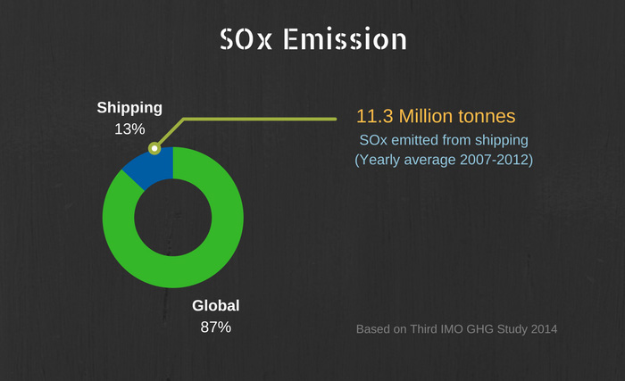
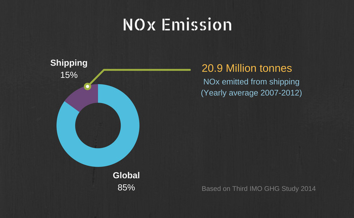
In the third IMO Green house gases study, MEPC noticed that shipping contributes to the 13% of the total SOx emissions.
When averaged for the years 2007 to 2012, a total of 11.3 million tonnes of SOx gases were emitted from the ships.
The question is, how SOx emission from the shipping can be reduced.
And there are only two possible ways
- Burn less or no fuel
- Use fuel containing as low sulphur as possible
Though optimizing speed for better fuel efficiency is encouraged by all the stakeholder, it is something that cannot be enforced upon.
The thing that can be enforced is the use of low sulphur fuel on board ships.
MARPOL Annex VI does exactly that.
As per regulation 14 of the MARPOL annex VI
The sulphur content of any fuel oil used on board ships shall not exceed the following limits:
- 4.50% m/m prior to 1 January 2012;
- 3.50% m/m on and after 1 January 2012; and
- 0.50% m/m on and after 1 January 2020.
Of course, the first limit of 4.5% m/m is no more valid as we are already past 1 January 2012 deadline.
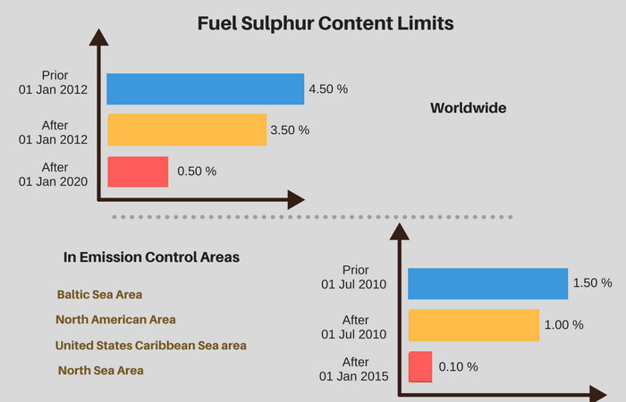
These limits are reduced when the ship is operating within an emission control area.
- 1.50% m/m prior to 1 July 2010; and
- 1.00% m/m on and after 1 July 2010;
- 0.10% m/m on and after 1 January 2015
Fuel Changeover procedures
When a ship is going to emission control area, it needs to change the fuel consumption to the low sulphur fuel as required.
This change over requires that before entering into the ECA, all the components of the fuel system must be using low sulphur fuel.
These components include
- Main engine
- Boilers
- Associated Fuel oil pumps
- Associated pipelines
Ship’s staff should be aware of the time required for this change over and how this fuel change over is to be executed.
Marpol Annex VI requires that
Each ship shall carry a written procedure showing how the fuel oil changeover is to be done. This shall allow sufficient time for the fuel oil service system to be fully flushed of all fuel oils exceeding the applicable sulphur content prior to entry into an emission control area.
Marpol annex VI also requires that record is maintained for all fuel oil change-over carried out before entry into ECA and after exit from ECA.
The record must contain at least the following information
- Tank wise Soundings and volume of low sulphur fuel oil
- Date, time and position fuel change over started
- Date, time and position fuel change over completed
- Date, time and position of entry into ECA
- Date, time and position on exit from ECA
2. NOx
As with the SOx, NOx too is the major air pollutant that is seriously harmful.
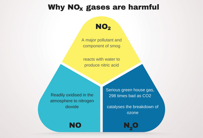
In the third IMO Green house gases study, MEPC noticed that shipping contributes to the 15% of the total NOx emissions.
But unlike SOx, NOx gases are not generated by burning the fuel but by the process of burning the fuel.
NOx gases are produced from the reaction of nitrogen and oxygen gases present in the air during the combustion process.
This reaction takes place at the high temperatures which the combustion of fuel in the engine provides.
So how the NOx can be reduced from the ship’s diesel engine?
It can only be reduced by the design of the diesel engine.
Well, I do not have a technical bone in my body so I won’t go into detail of what design changes can produce lesser NOx.
But for the purpose of understanding the requirements of Annex VI, we just need to know that NOx emission can be reduced by the better design of the ship’s engine.
Now there are certain NOx emission levels set by the MARPOL Annex VI. The requirements of these emission levels are divided into three tiers.
- Tier I
- Tier II
- Tier III
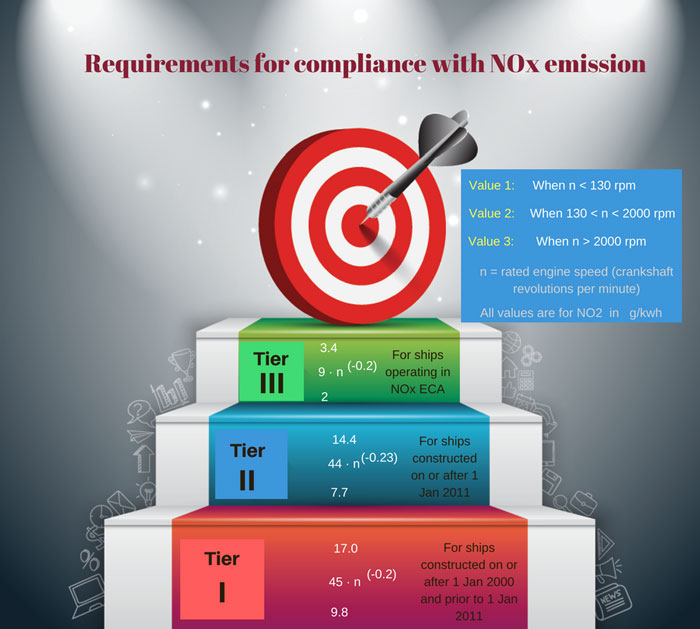
A Marine diesel engine that is installed on a ship constructed on or after 1 January 2000 and prior to 1 January 2011 fall under Tier I.
A Marine diesel engine that is installed on a ship constructed on or after 1 January 2011 fall under Tier II.
Tier III requirements are
- for the ships operating in an emission control area designated for Tier III NOx control
- for the ship is constructed on or after 1 January 2016 and is operating in the North American Emission Control Area or the United States Caribbean Sea Emission Control Area
Compliance with NOx emission
We have so far seen what NOx is and what Marpol Annex VI requires in terms of NOx emissions.
But the question is, how do we know if the amount of NOx gases emitted by the ship’s engine is within the required levels?
How do we prove the compliance with required NOx standards on board?
Compliance with NOx emission involves few parameters and records. Let us discuss this one by one.
Engine International Air Pollution Prevention Certificate (EIAPP)
Hearing about this certificate for the first time? Get your hands on this certificate next time you are on board.
EIAPP certificate must be present on board. And this certificate needs to be for each of the diesel engines more than 130KW on board.
Why 130KW?
Because the NOx requirements are applicable for diesel engines more than 13oKW power.
Now say, the ship is fitted with one main engine and three auxiliary engines (generators). There needs to be EIAPP certificate for all these.
Now, what does EIAPP certificate certify?
EIAPP certificate is issued after the engine is found to be complying with the NOx emission requirements during the pre-certification survey.
The pre-certification means the survey done before fitting the engine on board the ship.
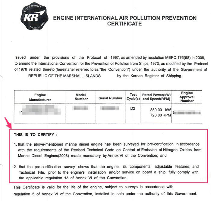
Having an EIAPP certificate on board shows that the engine fitted on board was complying with the NOx parameters and an engine of correct specifications was fitted on board.
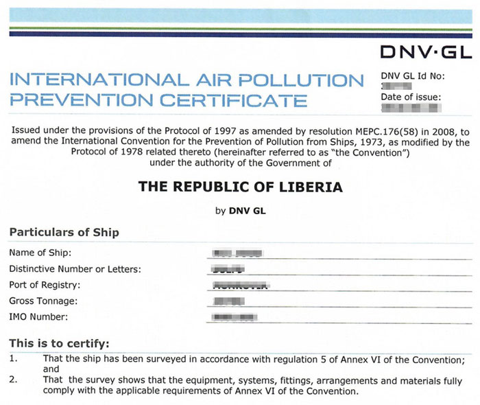
International Air pollution prevention certificate (IAPP)
After the engines are fitted on the ship, the test is again done on the engines for compliance with the NOx criteria.
This test is required because when the engine is fitted on board ships, some changes/modifications might have been done on the engines.
This test proves that the engine still complies with the NOx requirements even after fitting on the ship.
If the engines are found to in compliance with the NOx criteria of annex VI, International air pollution prevention certificate is issued to the ship.
NOx on board Verification
Having EIAPP and AIPP certificates on board proves that the engine of the correct specification is fitted on board.
It proves that when the engine was fitted on board, the NOx emissions from the engine were within limits and as required by MARPOL annex VI.
But how can we prove that even after 10 or 20 years in operation, the ship’s engines still comply with these requirements?
There are three ways in which ship can prove that it still complies with the NOx requirements.
- Engine Parameter Check method
- Simplified Measurement method
- Direct Measurement and Monitoring method
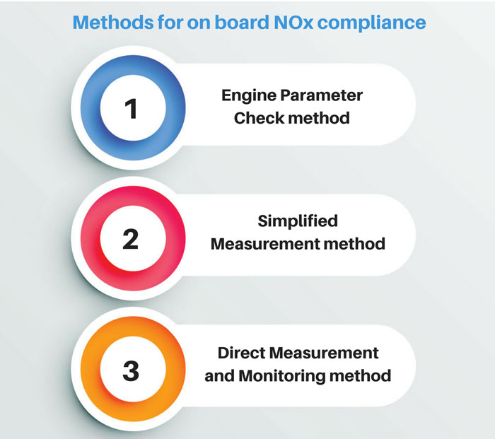
The method that the ship is certified to use for on board verification of NOx is specified in the EIAPP certificate of the engine.
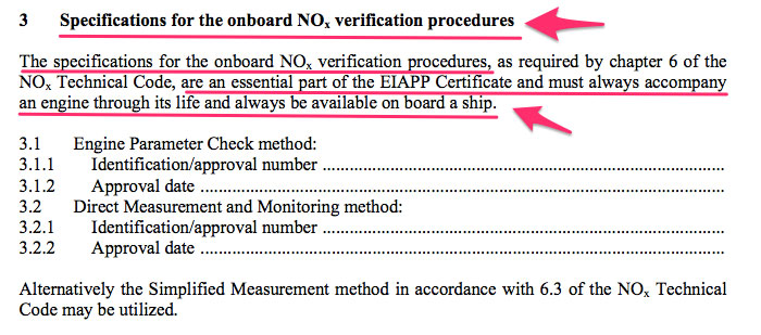
And the procedure to verify on board compliance (and using the certified method) is provided in the NOx technical file that accompany the EIAPP certificate of the engine.
The “simplified measurement” and “Direct measurement and monitoring” methods are based on measuring the NOx emissions from the engine.
Frankly, I seldom see these two methods used for NOx on board verification.
What I have mostly seen is the Engine parameter check method used on the ships for NOx on board verification. May be because of the simple principle it is based upon.
Engine parameter check method
This method is based on the principle that if the engine complied with the NOx parameters at the time it was fitted on board, it should continue to comply if there are no modifications/adjustment made to the engine.
This is really a simple and logical thing to say.
And as there are absolutely no extra costs involved to use this method, this method is most common among ship owners.
So there are few things that are required from this method that we must know.
- We must know the engine parts that contribute to the NOx emission. Modification and adjustments of these parts must be as per the Maker’s guidelines.
- If any of these spare parts of the engine need to be changed, it must be changed with the original part supplied by the maker.
- Any adjustments made to these parts must be within the range specified by the maker of the engine.
- A record must be kept of all the replacements of the spare parts and all the adjustments made to these parts.
Durning annual, intermediate and renewal survey of the Air pollution prevention certificate, these records, and engine parameters are checked by the class surveyor.
The international air pollution prevention certificate is endorsed or renewed on the basis of these verifications by the class surveyor.
NOx Technical file
So I said for the NOx compliance with engine parameter check method, the parameters of the engines need to be same throughout the life of the engine.
But where can we find these parameters for the engines fitted on board?
Where can we find the list of components that affect the NOx emission from the engine?
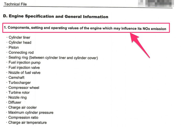
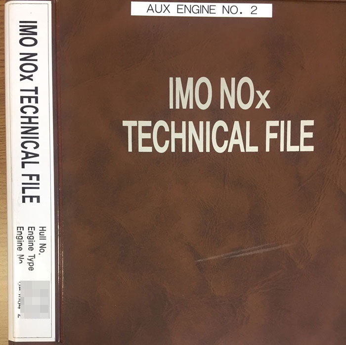
These all parameters are there in the NOx technical file.
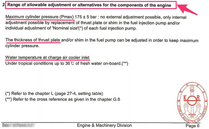
NOx Technical File is a record containing all details of parameters, including components and settings of an engine, which may influence the NOx emission of the engine.
So there is one NOx technical file for each engine for which an
EIAPP certificate is issued.
NOx technical file contains information about
- identification of those components, settings and operating values of the engine which influences its NOx emissions
- Allowable adjustments on the engine
- on board NOx verification procedures to verify compliance with the NOx emission limits during on board verification surveys
Conclusion
Marpol annex VI requires that ship must comply with the SOx and NOx emission requirements set out in the convention.
Seafarers must be aware of how to ensure compliance with SOx and NOx emissions.
Compliance with SOx is simple. Just use the fuel with sulphur content as per the limitation set for the area the ship is trading. Ship staff must have the procedures to change over from high sulphur to low sulphur fuels.
The compliance with NOx is ensured if
- the ship has EIAPP certificate for each of the diesel engine fitted on board
- The ship has a valid Air pollution prevention certificate
- All the components of the engine are maintained as per the NOx technical file provided on board for each diesel engine.
When we do so, not only we can sleep peacefully, we can also take pride for contributing towards making the earth a better place to live.
How to know if the anchor is dragging ?
Provided the ship has enough provision, water and fuel, everybody loves time at Anchorage.
Right?
We all love having the opportunity for a breather from the continuous cycle of loading, unloading and everything in between.
Even the environment on the wheelhouse is bit relaxed while the ship is at anchor.
But it is not unusual that the wind speed would start to increase, or for a nearby ship to drag her anchor or even own ship start to drag anchor.
The relaxed environment might become hair-raising, unexciting and spine chilling.
So let us face it. Keeping an anchor watch is only easy until everything is fine and the anchor is holding.
But that is not true if you know the signs to looks for to determine if the anchor is dragging.
Early detection of the dragging anchor situation can save a lot of trouble.
In this post, I will discuss the indications to look for to get an early warning of the ship dragging its anchor.
Let us jump in.
Anchoring a ship
The first thing that we need to know for keeping a good anchor watch is the position of the anchor.
And there is only one way to know this position.
By noting down the position of the ship when the anchor is dropped.
In the case of anchoring in deeper waters where anchor will be lowered with gear, it is the position of the ship when the anchor touches the sea bed.
It is the duty of the officer on watch during anchoring to note down this position.
It is good practice to note down this position along with the time of “let go anchor” in the movement book.
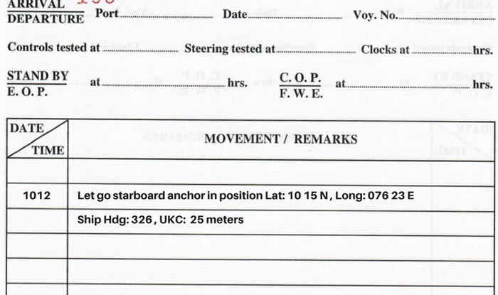
Another thing that we need to do is press the MOB button on the GPS when the anchor is dropped.
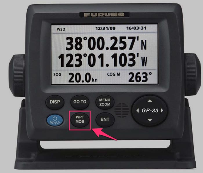
This will automatically save the position at the time of pressing the MOB button (anchored time). Usually, this position is saved as WP 999.
Swinging circle of the ship
Once we have the anchor position, we need to know the swinging circle of the ship while the ship will be at anchor.
This is important because no matter in which direction the ship swings, it will never go out of the swinging circle if the anchor is holding.
If the ship goes out of the swinging circle, the ship’s anchor is dragging.
Compare this with a cow tethered to a post. The cow can only swing on a circle with radius equal to the length of the rope she is tied to.
She can only go out of this circle when the rope has left the post.
Now coming back to the ship, the ship’s swinging circle at anchor is approximately equal to
distance from ship’s wheelhouse to forecastle + length of the anchor chain paid
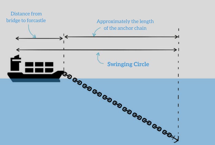
This is the approximate swinging circle as the 2nd distance is not exactly the length of the anchor chain.
But believe me, you do not want to be accurate to a couple of meters as you won’t be able to measure the movement of your ship to that accuracy.
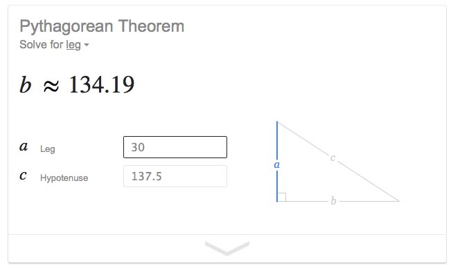
For example, considering a ship anchored in a depth of 30 meters with 5 shackles on deck, the error in the swinging circle (with the simple formula above) will be only 3 meters.
So now let us take an example to calculate swinging circle of the ship.
Let us say the distance from bridge wing to the forecastle is 150 meters. The ship is anchored with 5 shackles on deck.
So the swinging circle, in this case, would be
Swinging circle = 150 meters + (5 x 27.5) meters
This gives us swinging circle of 287.5 meters.
Now we want this to be in nautical miles. So divide this value by 1852 (1 Nautical mile = 1852 meters).
This gives us the swinging circle of 0.155 NM.
Importance of Anchor Alarm
I often ask this question on board to the duty officers. How would you know if the anchor is dragging?
And I often hear this answer, if the bearings (and range) of the fixed object changes, this would mean that we are dragging anchor.
While there is no doubt that this is one of the ways but this is not the answer I look for.
Why?
Duty officer would usually check the bearings once every hour.
So if anchor starts to drag at 2010 Hrs LT, the duty officer would only know about the dragging anchor at 2100 hrs LT when he would check the bearings.
We all want something to nudge us just when anchor starts to drag.
An alarm is the best way to get nudged.
So when I ask the duty officer, “How would you know if the anchor is dragging?”, I expect to hear this.
I will be warned by the anchor alarm that I have set and then I will confirm with the bearing of the fixed objects if the anchor is really dragging.
How to set the anchor alarm
Having an alarm warn you if the ship goes out of the swinging circle is good. But we must know how and where to set that alarm.
The anchor alarm needs to be set in the GPS.
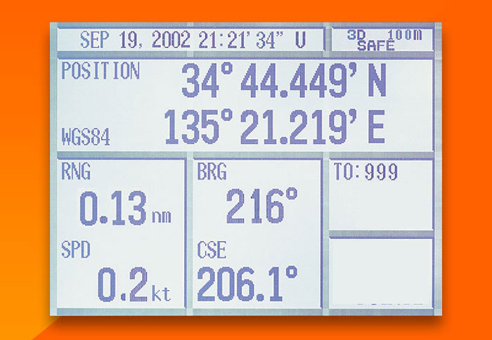
To set the alarm, first, we need to press “GO TO” on the GPS and then choose the waypoint 999 that we had created by pressing the MOB button at the time of dropping the anchor.
This will give us the ship’s distance (Range) from the anchored position.
If this range becomes more than the swinging circle of the ship, the ship’s anchor may be dragging as then the ship is out of the swinging circle.
But for the GPS to give us the alarm when the range to WP 999 becomes more than swinging circle, we need to
- Set the swinging circle value, and
- Turn on the anchor alarm
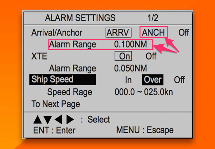
To do that we can go to the alarm settings on the GPS, turn on the anchor alarm and set the alarm range.
Mistakes to avoid while setting up the anchor alarm
While setting up the anchor alarm may seem simple (which surely it is), we sometimes make simple mistakes in this.
I do not want to list here the mistakes like alarm volume being too low etc. What I want to highlight is to test the alarm.
So if the actual range (to WP 999) is 0.13 NM, we should first set the alarm to less than this value (Say 0.09NM) and then see if the alarm sounds.
If it sounds, everything is alright.
We can then change the alarm range to the actual swinging circle we have calculated after anchoring.
Another mistake I often see officers making is to set the anchor watch on ECDIS without testing it.
On ECDIS the swinging circle and anchor watch can be set.
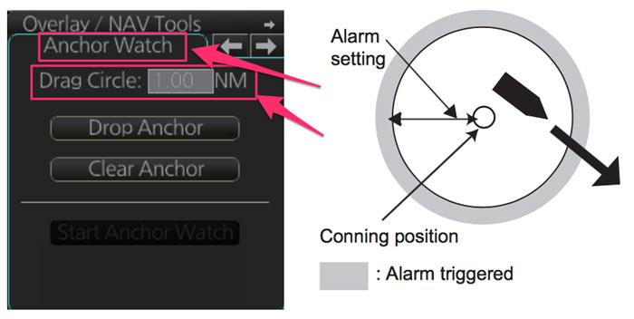
But not all the ECDIS give the audible alarm if the ship goes out of the swinging circle. Instead, these would just give a visual warning on the ECDIS.
So if we want to use the anchor watch function of the ECDIS,
- it must be used as a supplement to the GPS anchor alarm, and
- We must know if in case vessel goes out of swinging circle, the ECDIS would give the audible alarm or not
Ship position by bearings of fixed objects
By setting the anchor alarm we are making good use of available electronic aids.
But if possible, the visual bearing of two objects (or two points on the coast) is the best way to check the anchor position.
The two objects or points on the coast must not be on the same (or close to same) bearing lines. The bearings of these two objects must be separated by a significant angle.
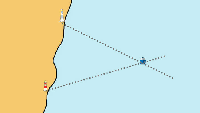
If available, these two fixed objects must be identified just after anchoring. If possible, the master should discuss the identifiable and conspicuous fixed objects with the duty officer before handing over the command to the duty officer.
Once identified, the bearing of these two objects is taken at least once every hour. If there is no significant change in these two bearing, the ship is holding its position.
Record the bearings in the anchor log.
Use of radar for anchor watch
We have discussed so far how to use GPS and Gyro (Visual bearings) to determine if the anchor is dragging.
Apart from that, the Radar is very useful equipment for monitoring anchor positions.
For using the radar for anchor watch requires radar conspicuous fixed objects. The presence of racon in the vicinity makes it even easier.
Straight coast with no edges is not useful for radar bearing.
If the radar conspicuous objects (or coast line) is available, bearing and range from this can be measured every hour.
 Another way that I see navigators make use of is with the EBL and VRM on the radar.
We can set the EBL and VRM on the radar and point it to the fixed object that we want to take bearing and range from.
If the EBL and VRM stay right there on the fixed object, the ship has not moved and the anchor is holding.
The good thing in this is that each time you have your eyes on the radar screen, you can easily make out in a flash if the ship is maintaining its position or not.
Ship’s speed as an indicator
Ship’s speed can be a good indicator of the dragging anchor.
A ship at anchor or when drifting will always head to the resultant of all the external forces (the wind, current etc).
When the ship’s anchor is holding, its speed over ground would be zero and speed through water will be equal to the current of the water.
But when the ship’s anchor is dragging, she would be moving with the flow of the current. In this case, ship’s will have some speed over ground but the speed through water will become close to zero.
So when the ship is dragging her anchor, she will have the negative speed over ground (GPS speed).
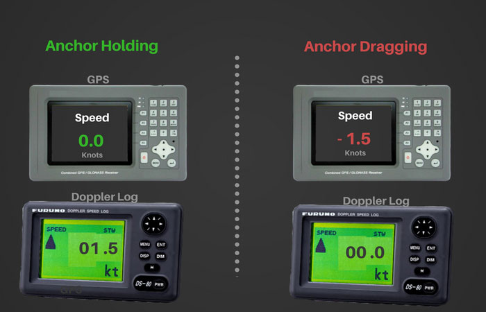
So when we are trying to look for an indication of dragging anchor, ship’s speed can be one of the things to keep an eye on.
But this will not hold good when the ship is swinging due to change of tide or wind direction.
When the ship is swinging, the GPS may show some speed. Faster the ship swings, more speed the GPS will show.
In this case, GPS speed may not be the indicator of dragging anchor. Just wait for the ship to steady its heading and then observe if the ship has some speed.
Flag on the anchor chain
Not all seafarers use the practice of tying up a flag on the anchor chain after anchoring.
And it is not a hard and fast rule to do that.
Let us understand the role of this flag.
There are two things we can do after anchoring.
- Rest the anchor chain on the bar, or
- Put the bar but keep it clear of the anchor chain
As per the mooring equipment guidelines, both methods have its merits and demerits and anyone of these can be used.
I prefer resting the chain on the bar.
If we choose to keep the anchor chain clear of the bar, it is good practice to tie a flag to the anchor chain.
If the flag falls down, this means the anchor chain has slipped and rested on the bar. This gives the indication that there is a lot of weight on the anchor chain.
This could be the first indication that the anchor may drag or is already dragging.
Watching the anchor chain
Watching the anchor chain in water is another way to know if the anchor is dragging.
As the ship is falling back, anchor is expected to hold the ship and stop it from falling back.
Ideally as the ship falls back, the anchor would stretch to the maximum capacity. That is, anchor will have the long stay.
Now if the anchor is holding and once it is stretched out, it will not allow the ship to fall back and will pull the ship forward.
As the ship moves ahead, the weight on the anchor will ease and finally rest at short stay.
But if the anchor is dragging, instead of pulling the ship forward the anchor would loose the sea bed and become up and down rapidly.
Ship will continue to fall back and anchor will again have the long stay.
So If the anchor is dragging, the anchor will continue to
- Go to long stay
- Rapidly come to up and down; and
- Again to to long stay
So if you suspect the anchor is dragging, send someone forward to watch the anchor chain.
If the anchor is behaving this way, you can think of that the anchor is dragging.
Conclusion
Dragging anchor is not something a watch keeper desires but it is something that may not be in control of the ship staff.
The anchor may sometimes drag.
Dragging anchor can lead to contact with other ship or grounding of the ship.
But all this can be avoided if the watch keeper is alert and knows about the indications of the dragging anchor situation.
Early identification is the key to avoid accident related to the dragging anchor situations.
Anchor dragging is totally acceptable situation provided it does not lead to an accident.
How an IMO convention enters into force and how it is amended ?

One thing that no seafarer can avoid is to not to deal with IMO conventions.
IMO conventions run the shipping trade.
Now try saying that ten times.
But seriously, without all these IMO conventions
- there would be many more accidents
- there would be much more pollution, and
- there would be many more sub-standard ships
I say this even when I am of the opinion that few of the IMO conventions are poorly implemented in the industry.
But for we seafarers who are not maritime lawyers, the process of IMO conventions confuse us.
After all, there are so many terms associated with the IMO conventions.
Protocol, code, resolution, treaty, convention, circulars, amendments and much more.
Confusing right?
Well, I am not writing this post to define all these terms. I have already written on a couple of these terms in my earlier posts.
Few of these posts are here for quick reference.
- Understanding IMO Conventions, Resolutions, and Circulars
- Treaty and Convention, How These Two Are Different?
- What is the difference between a Convention and a protocol?
- What the difference between a treaty and a convention?
But what I am here to discuss today is the process birth of an IMO convention and how and when it is amended.
Let us start.
Need for a new IMO conventions
Before we discuss anything about IMO conventions, we need to know who decides if a new IMO convention is required?
Let us think of few of the IMO conventions. What triggered the need for these conventions?
SOLAS: The sinking of Titanic and loss of more than1500 people triggered the need of a convention that could look into the safety issues. That led to the formation of SOLAS convention.
MARPOL: Grounding and oil pollution from oil tanker Torrey Canyon alerted the world to the dangers of oil tankers. This incident and many other oil pollution incidents in mid 60’s led to MARPOL convention.
ISM: The sinking of Herald of free enterprise highlighted the issue of “Human error” and IMO responded with the introduction of ISM code.
Ballast water convention: Various studies found that when ballast water is a dangerous source of the relocation of many organisms in water. If suitable conditions exist in this release environment, these species will survive and reproduce and become invasive species.
In many cases, these organisms can become a dominant species by the extinction of native species. That can have negative effects on public health and industries that rely on this water.
We can see from these conventions that whenever a weak link is identified in the shipping trade, IMO brings a convention to address that.
The weak link can be identified either
- by a major shipping incident or a trend of smaller incidents
- by a major research work
Even the enhanced survey programme was introduced as a result series of loss of the bulk carriers because of structural failures.
Bottom line is that whenever IMO finds any weak link, it responds with either bringing a new convention or amendments to the existing convention.
How a new IMO convention enters into force?
When the IMO identifies a need for a new convention, it starts the process of bringing it into force.
But bringing a new convention into force is not so easy.
The mere fact that the ballast water convention entered into force after 13 years of its adoption would suggest how hard it may be for the IMO to bring a new convention into force.

Entry into force of an IMO convention is a lengthy process. And it starts with a suggestion from one of the members in the session of the committee. This is followed by a process to create a draft convention.
1. Draft convention
The session of the committee is held every 6 months. Based on the information and research, any member state can propose the need for a new convention.
If satisfied with the merits of the proposal, the committee will forward the proposal to council or assembly as required.
If the Council or Assembly accepts the proposal, it would authorize the committee to proceed with the work.
The committee will then work on this proposal in detail and will draw a draft convention.
This draft convention is then sent to the Council and the Assembly. At this point, the committee would also recommend the Council and Assembly for a conference for the adoption of the convention.
2. Adoption of the convention
The Council or the Assembly would set a date for the conference for the adoption of the convention and communicate this date to all the member states.
The draft convention is also circulated to all the member states for their comments. The committee examines the comments (if any) from the various member states to amend the draft convention before the conference.
In the conference, the amended draft convention is presented to the member states.
Once the majority of the member states present agree with the final draft of the convention, it is formally considered adopted.
The adopted convention is then sent to the Secretary General of the IMO who sends the copies to all the member states.
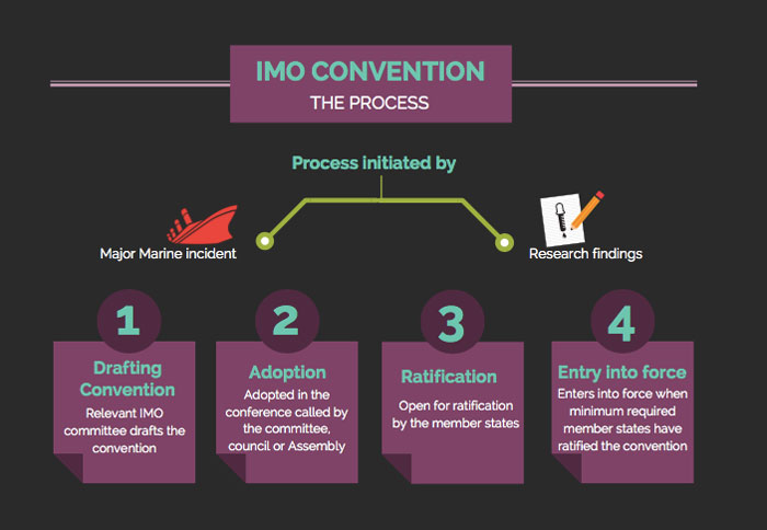
3. Ratification of the convention
An adopted convention is still not binding on the member states. The convention needs to be ratified.
The required conditions for this adopted convention to be considered ratified are pre-agreed during the drafting process.
These conditions are in one of the articles of the adopted convention.
For example, Article 18 of the Ballast water convention has set the conditions for entry into force of the convention as
The convention will enter into force 12 months after ratification by a minimum of 30 States, representing 35 percent of world merchant shipping tonnage.
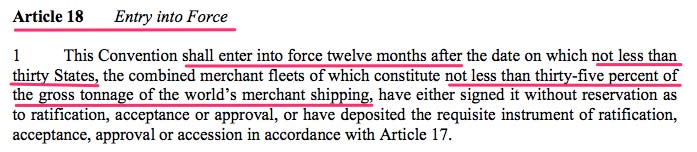
How many states and how much tonnage percentage for ratification is decided by the committee and agreed by the member states during the adoption process.
Generally, the stricter convention would require more number of states and tonnage to ratify the convention for its entry into force.
4. Entry into force for the convention
A convention would enter into force when a minimum number of member states accepts it.
But how do a member state can tell the IMO that they accept an adopted convention?
There are few ways.
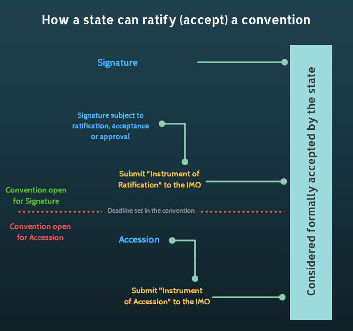
By Signature
If the convention allows, the most formal way of showing the acceptance of the convention is by a simple signature.
In this method, the representative of the member state signs on the sheet provided by the IMO.
The member states can also sign with a remark such as
signed subject to ratification, acceptance or approval
This would mean that the state wants to sign the convention but it must first be accepted or approved by the parliament of their own state.
IMO allows a certain period to the member state for showing their acceptance to the convention by signature.
By Ratification
If a member state has signed the convention subject to ratification, acceptance or approval, this member state would not be considered to have shown its consent for the convention.
This means that IMO would still not consider this state as the one which has ratified the convention.
This member state is required to deposit a document called “instrument of ratification” to the depository of the convention.
In simple terms, the depository is the department which keeps the track of member states that have ratified the convention.
By Accession
IMO sets a time frame (say, 12 months after adoption) for the acceptance of the convention by signature.
After this time frame is over, the member states can show their consent by accession.
Accession is the method used by a State to become a party to a treaty which it did not sign whilst the treaty was open for signature.
A member state is considered to have become the party to the convention when it deposits the “instrument of accession” to the depository of the convention.
For example, Ballast water convention was to enter into force 12 months after ratification by a minimum of 30 States, representing 35 percent of world merchant shipping tonnage.
As of Jan 2016, the convention was ratified by more than 30 states but it still was short of 35% of world shipping tonnage.
In September 2016, when Finland submitted the “Instrument of accession” to the IMO the conditions required for the ratification of Ballast water convention were met.

Following the accession by Finland, the ballast water convention entered into force on 04th Sept 2017.
5. Implementing the Convention
After the convention has been ratified by the required number of states with the required total tonnage, it would enter into force after a pre-defined time.
For ballast water convention, this time was set at 12 months after ratifications of the convention.
This time is used to prepare for the implementation of the convention.
The member states which have ratified the convention need to include the convention in their country’s law.
This means that the state needs to amend their “merchant shipping act” (if that is what this law is called in that country).
When the convention finally enters into force, the countries that have ratified the convention would have the provisions of the convention included in the country’s local laws.
This way the convention becomes legally binding on the ships that fly the flag of the contracting states to the convention.
How is an IMO convention amended?
A convention that is relevant today may require some changes for it to be relevant after few years.
IMO not only works to bring new conventions but also continuously works on improving the existing conventions.
This may require the existing conventions to be amended.
Broadly there are two ways a convention can be amended.
- By a resolution to the convention
- By a protocol to the convention
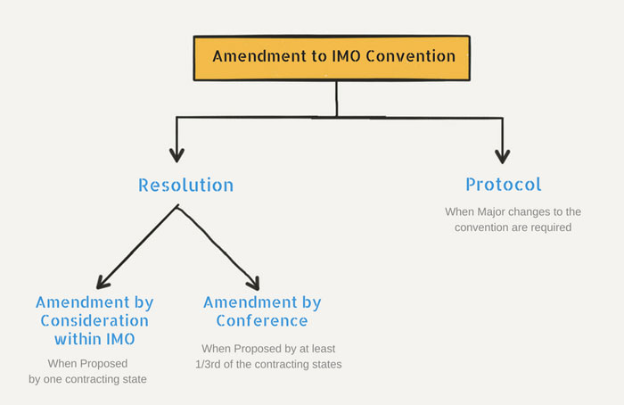
1. Amendments by resolution
There are two ways to initiate the process of amendment by passing a resolution.
- By consideration within the IMO
- By Conference of the contracting states
By consideration within the IMO
Let us look at the stages of process of amendments of a convention by consideration within the IMO.
Proposal
The proposal for amendments of a convention can be initiated by any contracting states. The proposal is made to the secreatary general of the IMO
The SG would pass the amendment proposal to MSC or MEPC for review.
MSC or MEPC would draft the resolution and submit the resolution for adoption.
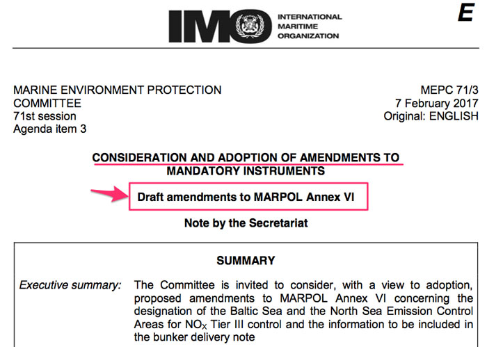
Adoption of resolution
Once MSC or MEPC have the draft of the resolution, these are forwarded for adoption.
Resolutions are adopted by voting in Maritime safety committee or Maritime Environment Protection Committee.
For successful adoption of the resolution
- At least one-third of the contracting governments should be present for voting.
- At least two-third of the contracting governments present should vote in favor of the resolution.
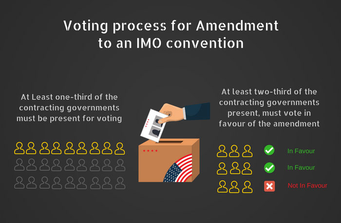
Acceptance of resolution
The adoption process requires the presence of only one-third (at least) of the contracting states. But for acceptance of the resolution, the majority of the states need to agree on the resolution.
The most common way of acceptance of a resolution is “tacit acceptance”.
As per the “tacit acceptance”, it is implied (assumed) that a contracting state has accepted the resolution if it does not oppose it within a particular time frame after the adoption.
The conditions of the acceptance of a resolution are provided in one of the articles of the original convention itself.
2. Amendment by Conference
In this way, a group of at least one-third of the contracting governments need to propose the amendment to the relevant committee of the IMO.
The committee would then call for a conference of all the contracting states for that convention for the adoption of the proposed amendment.
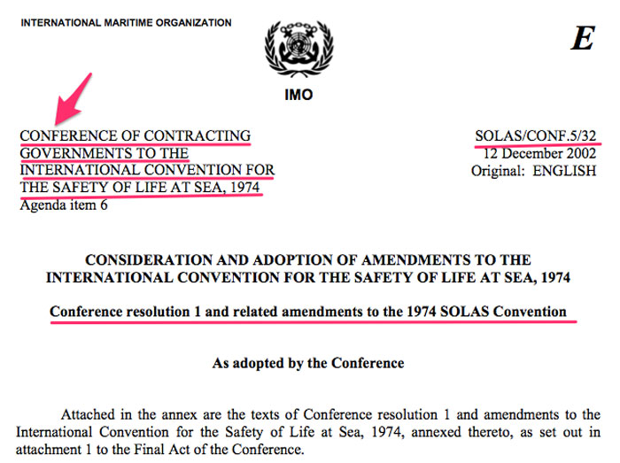
The process of adoption and acceptance is similar to what we discussed earlier under “amendment by consideration within the IMO”.
This is the fastest way to bring an amendment to a convention.
Why?
Check out the two conditions for the adoption of an amendment.
1. At least one-third of the contracting states must be present for voting.
As one-third of the contracting states have proposed the amendment, they all would most certainly be present for voting.
2. At least two-third of the contracting governments present should vote in favor of resolution
Even if all the contracting states were present for voting, the one-third are already sure of voting in favor of the amendment.
3. Amendment by Protocol
The protocol is not exactly an amendment. It is a convention within a convention.
Sometimes a change is required in the convention that is too significant to be amended by a resolution.
Few example of these significant changes can be
- a change that is applicable to the all the chapters of the convention.
- A change to include a new area in the convention (for example inclusion of Annex VI in the Marpol)
- the entire convention needs to be reworked.
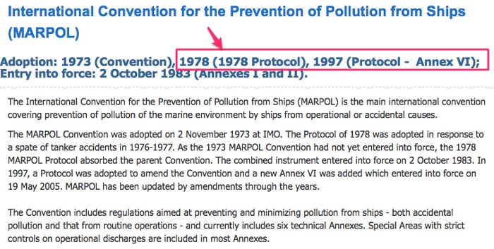
Protocol to the convention brings major changes to the convention.
The states that had ratified the original convention may not accept the protocol to the convention.
For this reason, the protocol to a convention enters into force in the same way as a convention would have.
This means that a particular number of states with the certain percentage of world’s tonnage need to ratify the protocol for it to “enter in force”.
Even when a protocol enters into force, it will only be binding to the countries that have ratified the protocol. It will not be binding on all the contracting states to the original convention.
As you can see that out of 163 countries that ratified the SOLAS convention, 43 countries still have not ratified the 1978 protocol to the SOLAS convention.
And 53 countries that ratified the SOLAS convention have till date have not ratified the 1988 protocol to the SOLAS convention.
Conclusion
Among many other things, IMO’s work include creating new and amending existing conventions to help ships face the challenges at the sea.
As seafarers, to understand the signficance of these conventions we must understand how these conventions are brought and how these conventions are amended.
8 simple Mistakes Navigators make while using Traffic Separation Scheme

Next time you are navigating in the Singapore Strait, just imagine if there was no traffic Separation scheme in that area.
Or imagine crossing the Dover Strait without the presence of any Traffic separation zone.
It would be chaos.
The increase in accidents would be many folds.
And you would say Hell no, it is so difficult to navigate with TSS in these areas, leave alone navigating without TSS.
I could not agree more.
There are 205 plus Traffic Separation Schemes adopted by the IMO which suggests that even if you have been sailing for only a couple of years, you would still have been in a TSS.
But if you have not then let me clear the air right away.
The purple zones and line that you see for TSS are only the imaginary lines drawn on the chart and you won’t find these marked on the sea water as your chief officer might have asked you to look for.
TSS makes the navigation a little easier but that also brings complacency that leads to seafarers making simple mistakes while using TSS.
Don’t trust me? Then hear this.
In 2017 alone, there have been a number of major collisions in the TSS. One of those was the infamous collision between MSC Alexandra and the Dream II in Singapore Strait.
Worried by the number of accidents in Singapore Strait, MPA Singapore even released a video on the Safe passage in the Singapore Strait.
So the question is how to avoid all these troubles when navigating in TSS? By avoiding simple mistakes that we might be making in the TSS, I would say.
In this post, we will discuss 8 of these simple mistakes that seafarers make while using TSS.
1. Joining and leaving a TSS
If we have to use a Traffic Separation Scheme, the first thing we have to do is to join that TSS.
But there are few mistakes that seafarers make while joining a TSS.
As per Rule 10 of the Colregs
normally join or leave a traffic lane at the termination of the lane, but when joining or leaving from either side shall do so at as small an angle to the general direction of traffic flow as practicable
What does this mean?
This means that we must join the TSS at or before the point where it starts.
I know you know that. But the mistake I will be pointing out is not that but this.
 Do you see any issue with this course in and around TSS?
The ship has planned to enter and leave the TSS at the termination of the TSS as required by rule no 10. Everything looks OK but there is one issue with this course.
The issue is that the ship has planned the to exit the TSS at a course that would trouble the ships about to join the TSS.
The solution to this issue is…
Do not plan to alter the course towards the traffic planning to join the TSS. We can plan to continue to move on our course for a couple of miles and then alter the course.
In fact, this is exactly what rule 10(f) emphasizes on.
2. Crossing the TSS
I earlier said that TSS makes it so easy to navigate in congested waters. But that is not true if you need to cross a TSS.
Don’t trust me then try crossing the TSS to pick up the pilot at Singapore.
The part of the TSS where there is expected crossing traffic is marked by a precautionary area.
Consider that your ship is arriving from the west and need to pick up the pilot at “Western pilot boarding A”. You need to cross the TSS to pick up the pilot.
Now the mistake I see many seafarers do is to plan the crossing this TSS like this.
This course may have the advantage of easily arriving at the pilot station with heading 090 (parallel to the breakwater).
But we must understand that we cannot cross the TSS at this angle.
As per the Rule 10,
A vessel shall, so far as practicable, avoid crossing traffic lanes but if obliged to do so shall cross on a heading as nearly as practicable at right angles to the general direction of traffic flow
3. Using a wrong TSS
I know a couple of instances where the port authorities fined the seafarers and the company for using a wrong TSS.
What do I mean by the wrong TSS?
At few places, you will find two Traffic separation schemes at the same place. That is two TSS in an upward direction and two in the downward direction.
Which TSS do we need to follow?
We just need to check the information on the chart and/or sailing directions for that area. This will have the information about each of these TSS.
The information could be something like this.
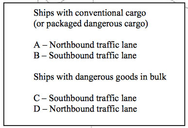
So if the ship is carrying dangerous cargo in bulk, the ship must use the lane C if southbound and lane D if northbound.
But I must be a silly person if I think that seafarers just follow the lane as per their choice.
Then why do they make this mistake?
While sometimes it may be just because of negligence, other times there may be other reasons.
The reasons like following the previously used passage plan. When the last time this TSS was used, the vessel may be loaded with dangerous cargo in bulk.
The next time, the vessel may not have dangerous cargo in bulk. But as the previous passage plan was used, vessel followed the wrong lane.
But whatever the reason, it cannot be an excuse for using the wrong lane.
4. Missing Mandatory reporting
Using some of the TSS require the ships to do certain reporting. For some, the reporting is required just before joining a lane and on the VHF.
For others, it may be required a couple of days before entry into the TSS and through the email.
For example, using Dover Strait require all the vessel over 300 GRT to do mandatory reporting.
Singapore and Malacca Strait is another TSS that have the mandatory reporting requirements.
There are tons of resources seafarers can refer while planning the passage that requires using TSS.
For Dover Strait, there is BA chart 5052.
For Malacca Strait, there are a couple of resources that seafarer must refer. Resources like
- Admiralty Charts, 5502-Mariners’ Routeing Guide Malacca & Singapore Straits
- Passage Planning Guide – Malacca and Singapore Straits (by Witherby Publishing Group)
And then there is this brief guide by BIMCO for safe transit through the Strait of Malacca and Singapore.

It is unfortunate that there have been many cases where this mandatory reporting is either missed out or VHF volume is too low to hear the calls made by the VTS monitoring the TSS.
5. Not acting Proactively in TSS
If you ask me to name one quality that seafarers should develop in themselves, I would choose proactiveness with all the force I can.
While a navigator needs to be proactive in every aspect of navigation, navigating in TSS is particularly the area where this trait is very useful.
Let us see it with examples.
Do you see anything wrong with this courses in the Singapore TSS?
While there is nothing wrong with the course per se but I know the OOW (or master) of this vessel may have a tough time crossing this area.
How do I know?
There would be a lot of traffic leaving the anchorage area and joining the opposite traffic lane.
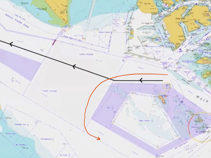
With this course, we are creating a situation where some of this traffic might be crossing our bow.
This would be apart from the usual traffic that will be crossing the TSS for picking up the pilot.
A similar case is when you have to cross the Singapore TSS for picking up the pilot. If you plan your course like this, you are inviting troubles in crossing the TSS.
Why?
Because you will find it hard to alter your course to cross the TSS because of usual traffic in the TSS.
Then, what if we plan our course like this?
Surely, we are avoiding a lot of cross traffic this way.
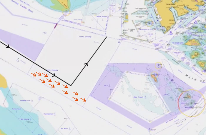
All I am trying to say is that we need to be proactive in planning our passage in the TSS.
6. Not keeping the vessel TSS ready
Your company’s SMS manuals may or may not specifically mention this. But there are certain rules in navigating a vessel in the TSS, especially a congested TSS areas.
These rules are
- Keeping an extra A/E (generator) running, and
- Proceeding at a safe speed
Why? Let me explain.
Keeping an extra A/E (generator) running
When the ship is navigating in the TSS, there are a hell lot of vessels around own vessel at a comparatively shorter distance.
I agree that most of these vessels are on a parallel course to the own vessel.
But should anything goes wrong with any one vessel, we may be in need to alter our course quickly. This may require us to use the rudder hard over.
If the extra A/E is not running, the vessel may experience black out just when it requires the power most.
Proceeding at a safe speed
Sudden alteration of course may be required in the TSS but sometimes that is not the most effective action in the TSS. This may be because of dense traffic around, the width of the TSS or wrecks and other dangers around.
This will be the time when reducing (and sometimes increasing) the speed may be the most effective action.
But what if you are proceeding at the sea speed and need to give notice to the engine room (say 30 minutes notice) for reducing the speed?
In the open sea, alteration of course may be the best way to avoid the collision. But in TSS, it may sometimes be the reduction in speed.
Proceeding at full sea speed in the TSS will not be the safe speed.
7. Misunderstanding the Rule no 10
I hear a lot of questions on TSS situations. Questions like
- A vessel crossing own vessel from starboard (or port) side in TSS with the risk of collision. Who is give way vessel and what action we need to take?
- A fishing vessel crossing own vessel in TSS. Who is give way vessel?
- A NUC vessel overtaking own vessel in TSS. Who is the give way vessel?
And hundreds of similar situations. Sometimes we fail to gather that all these situations can be covered under a single answer.
And the answer to all these questions is…
a traffic separation lane does not give any right of way to any vessel over any other vessels
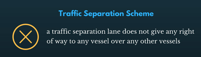
This means that you should treat all TSS situations as if the same situation was in the open sea.
So action in case of crossing situation in TSS will be same as a crossing situation outside TSS.
Similarly, the action for the overtaking situation in TSS will be same as any overtaking situation outside TSS.
I might sound a bit repetitive here but I would still say it again.
a traffic separation lane does not give any right of way to any vessel over any other vessels
8. Not following general traffic flow
Again, this is the mistake I see too often. We plan the passage in the TSS that is not following the general traffic flow.
Want to know what I am talking about here?
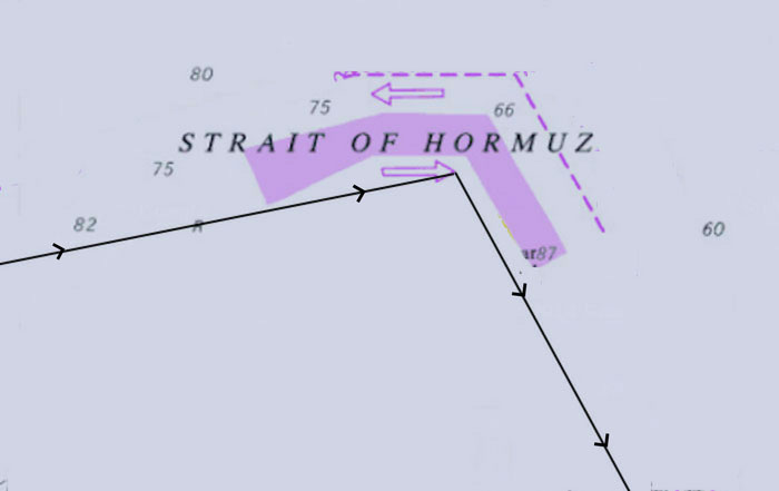
We all know why this is done purposely.
To avoid one extra line or course.
But we must understand that this is wrong and not as per rule 10 which states that
A vessel using a traffic separation scheme shall proceed in the appropriate traffic lane in the general direction of traffic flow for that lane
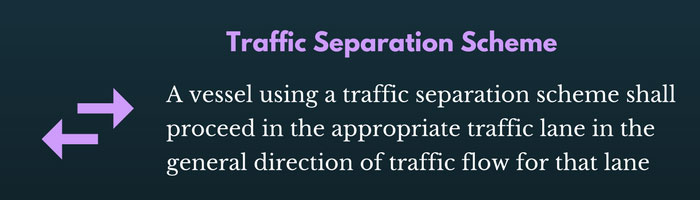
It may take us a couple of more lines to draw, but ideally, we must bend our courses parallel to the TSS.
Like this, for Strait of Hormuz.
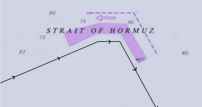
Conclusion
I said it in the beginning and I would say it again. TSS makes the navigation much easier.
But that is only if we use the TSS in a way that not only avoids troubles to us but to other vessels in the TSS too.
We have discussed the 8 simple mistakes that navigator make while using TSS.
Avoiding these mistakes can save much of these troubles in the TSS.
Here is All You Need to Know About EU MRV Regulation

In today’s time, it would be hard to believe that there was a time when sailors could legally throw oil in water.
That stopped with the adoption of annex 1 of the MARPOL.
Other wastes like chemicals, domestic garbage and sewage stopped soon after.
But in recent times, the emphasis has been on two sources of pollution
- Air pollution and
- Pollution from the ballast water
Annex VI of the MARPOL aimed to control NOx and SOx component from burning of fuel.
Then where does this new EU regulation fit?
EU MRV is aiming to control the emission of CO2 from the ships. In this post, I will discuss how EU MRV aims to do that and what is required out of this new regulation called EU MRV.
What is EU MRV?
Right now this regulation does not define the maximum level of co2 emission that is allowed for the ships. Instead, it just focuses on three aspects of co2 emission
- Monitoring
- Reporting
- Verification
That is exactly what MRV stands for.
The questions that would come to our mind are,
- Specifically, what needs to be monitored
- how exactly this need to be monitored
- To whom this data needs to be reported
- Who needs to verify this data
The EU Regulation (EU 2015/757) lays down all the rules that answer these questions.
I will answer these question right here but first, we must know to which ships this EU MRV regulation is applicable for?
EU MRV regulation is applicable for
- All commercial ships of more than 5000 GRT, irrespective of flag, and
- operating into, out of or between a port of call in EU (EU member nations, Norway and Republic of Iceland)
[Source]
What to Monitor?
The aim of the EU MRV is to measure CO2 emission from a ship. But it has to be a value that can be compared with the other ships. And based on that data a conclusion of which ship (or the company) is greener than the other.
Now take these two examples of annual CO2 emissions from two ships
- 6000 T of CO2 emission from Ship A
- 3000 T of CO2 emission from Ship B
Which ship is greener with respect to CO2 emission?
You may be tempted to say that Ship B is greener and more environment-friendly than the ship A but that may not be true.
Here is why!!!
The ship B though have produced lesser CO2 but what if ship B has been at anchor most of the time? If so, she ought to have a lesser CO2 emission.
Similarly, if ship B was always half loaded, she ought to consume lesser fuel and thus emit lesser CO2 compared to ship A which is always operated at the fully loaded condition.
So with EU MRV what we are looking at is not the measuring of CO2 but measuring the “average energy efficiency” with respect to CO2 emission.
To calculate the “Average energy efficiency”, apart from CO2 emission we need data like
- Distance traveled
- Time at sea and in port
- Cargo Carried
As per EU MRV, for each ship following data need to be measured
- Port of Departure/Arrival including date/time of departure/Arrival
- Amount of each type of fuel consumed
- Distance Travelled
- Time at Sea
- Cargo Carried
With respect to ship’s staff, there is nothing new in this data. Most of the ships have this data in the voyage reports.
How to Monitor?
We can calculate the each type of fuel consumed by the ship during a particular period. But how do we calculate the CO2 emission?
Annex I of the EU MRV regulation has the answer. As per Annex I of the EU MRV regulation

Annex I of the EU MRV also provides the default values of the emission factor of the different type of fuels.
But the ship owner needs to know the emission factor of fuel being used on board their ships.
When to Monitor?
Ship needs to monitor and report the data on two occasions
- At the end of each voyage, and
- At the end of each year
Voyage reporting need to have at least the following data
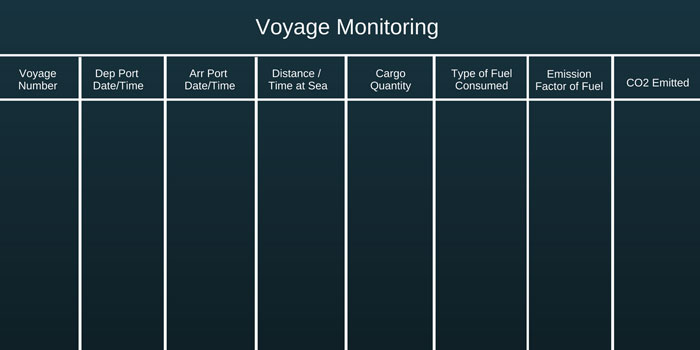
At the end of the year, data for the entire year need to be compiled.
From the seafarer’s point of view, they just need to report the voyage data and annual report will be compiled by the company.
Some companies have integrated the required data with the noon-reporting software that the company is already using.
For example, Wilhelmsen ship management has integrated the required data in the noon report tool.
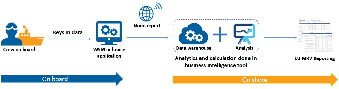
So the seafarers just need to enter the noon report data in this tool. Compilation of data and generating voyage report and annual report is done on shore.
Here is how the generated annual report and voyage report looks like.
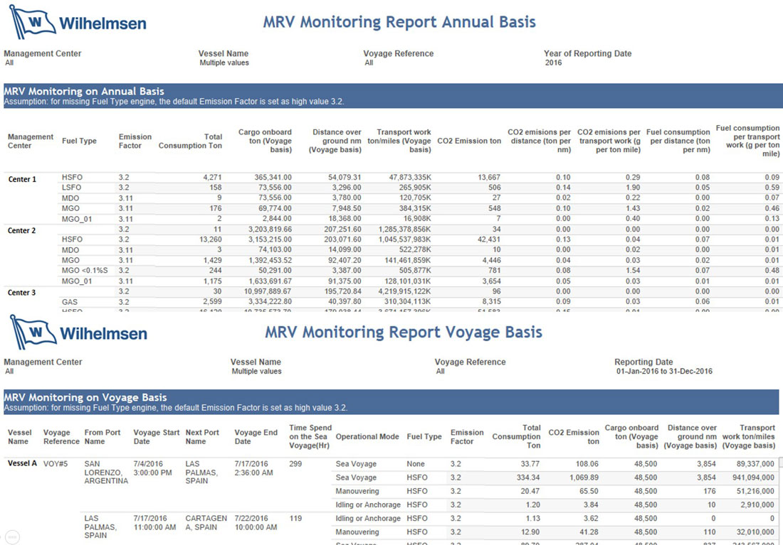
[Source] [Click for enlarge view]
Instatech marine has developed a way for automation of this whole process, that requires no or minimal manual entries.
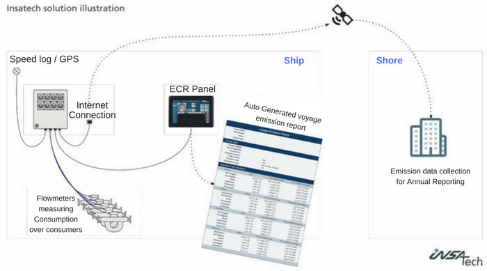
Monitoring plan
Another important aspect of EU MRV is the development of monitoring plan for each ship.
The company is responsible for the development of the monitoring plan for each of their ships for which EU MRV regulation applies.
The monitoring plans deal with the specific information on “what and how” of compliance with EU MRV for that ship.
Briefly, the monitoring plan will highlight
- All the possible sources of CO2 emission from the ship (main engine, Aux engines,
- The procedure of monitoring fuel consumption. For example, if the fuel consumption will be calculated by manual soundings or by flow-meter? Which Fuel density to use, that mentioned in BDN or in the fuel analysis report?
- What emission factor to use?
- Procedure to calculate the distance covered by the ship (Will the source be from GPS, AIS
- Procedure to calculate the quantity of cargo carried. For example what cargo quantity to use (B/L, ship figure, Vessel experience factor to be applied or not etc)?
This monitoring plan needs to be developed by the company and then submitted to an independent verifier for assessment and approval.
Few Verifiers have created tools for generating the monitoring plan the shipping companies.
In reality, most of the companies appoint the verifier itself to develop the monitoring plan on their behalf.
EU MRV has set 31st Aug 2017 as the deadline for submitting the monitoring plan to the independent verifier.
But what about the ships that do not trade in EU ports and later at some point of time need to call one of the EU ports?
EU MRV regulation, article 6 has the answer for this
for ships falling under the scope of this Regulation for the first time after 31 August 2017, the company shall submit a monitoring plan to the verifier without undue delay and no later than two months after each ship’s first call in a port under the jurisdiction of a Member State
Emission Report
As we discussed, the ships need to monitor and report the data as per the monitoring plan of the ship every voyage and then annually.
The data of the annual report need to be sent to the European Commission through a report called “emission report”.
The emission report needs to be assessed by the verifier before it is sent to the European Commission.
Apart from the data in the annual report, the emission report would contain
- The detail of the ship and the company
- Detail of the Verifier who assessed the emission report
This emission report needs to be transmitted electronically to the European commission.
The first emission report must be transmitted by 30th April 2019 and subsequent reports on the same date each year.
Document of Compliance
Another element of the EU MRV regulation is the “Document of Compliance”.
The essence of the EU MRV regulation is the emission report sent to the European commission.
The whole purpose of EU MRV regulation would be lost if
- the emission report does not contain the data as required by EU MRV regulation, or
- the data in the emission report is not in the format that is required by EU MRV regulation
To ensure that the data and format of the emission report are as per the EU MRV regulation, the emission report is required to be assessed by an independent verifier.
If the emission report is as per the EU MRV regulation, the verifier would issue “Document of Compliance” to the ship.
The first document of compliance would be issued on or before 30 June 2019.
Document of compliance is valid for a period of 18 months after the end of reporting period.
So for the first reporting period (01st Jan 2018 to 31st Dec 2018)
- The document of compliance will be issued on or before 30 June 2019,
- The document of compliance will be valid until 30th June 2020
Role of the Verifier
Apart from monitoring and reporting parts, EU MRV has this third important part. That is of verification.
Under EU MRV regulation, the verifier has an important role. EU MRV Regulation defines the Verifier as
a legal entity carrying out verification activities which is accredited by a national accreditation body pursuant to Regulation (EC) No 765/2008 and this Regulation;
So the verifier needs to be
- independent entity and not in any way related to the ship owner and the company
- accredited by a national accreditation body. This ensures that verifier has the know how of monitoring and reporting of environmental data.
Who is the Verifier?
There are many companies acting as Verifier for EU MRV and a shipping company has to make a choice to choose a verifier.
Most of the classification societies have acquired the required accreditation and can be used as a verifier for EU MRV.
But there are other companies that only specialize in EU MRV regulation. Verifavia shipping is one of the examples.
There are two major tasks of the verifier
- Assessment and verification of Monitoring plan, and
- Assessment and Verification of emission report
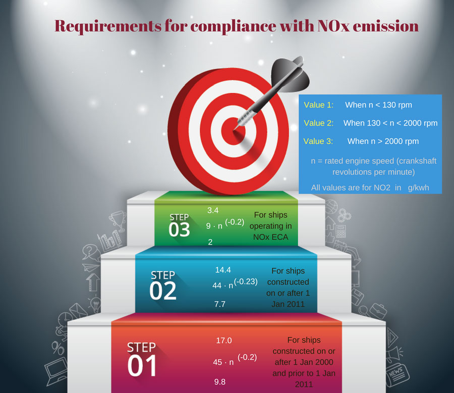
Assessment and verification of Monitoring plan
Verifier needs to assess that the monitoring plan of the ship is as per the EU MRV regulations.
Any non-conformities identified during the assessment of monitoring plan are communicated by the verifier to the company.
The company then needs to amend the monitoring plan and submit the revised plan to the verifier for the verification.
Assessment and Verification of emission report
We have already discussed this. The verifier needs to assess the emission report of the ship before it is submitted to the European Commission.
Verifier needs to assess the emission report for any misstatements, non-conformities and/or any errors. If any found, same are reported to the company for corrections.
Verifier would issue a verification statement when the emission report is in line with the EU MRV regulations.
Based upon this verification report, verifier issues the document of compliance as required by EU MRV.
Publication of data by European Commission
What would European Commission do with all the ship data that they will collect?
Well, they will publish the data publically on a website. That means anyone can have the access to this data of any ship of any shipping company.
This aspect of the EU MRV regulation has been controversial.
Ship owners are worried that shippers would use this data for further negotiating the freight rates based upon the level of CO2 emission by that ship or the ships of that company.
So the ship and the company that produces less CO2 may comparatively get higher freight rates compared to other ships/companies.
And I think that is the whole purpose of European commission to publish the data publically. To put pressure on the shipping companies to reduce their CO2 foot print.
IMO fuel consumption data collection system
Following the European Commission, on 28th October 2016 MEPC of IMO adopted an amendment to the Annex VI of the MARPOL.
This new amendment requires ships of more than 5000 GRT to report fuel consumption data to the ship’s flag.
Well, I will not discuss here this new IMO requirement but what I want to emphasize here is that there are many overlapping areas between EU MRV and IMO fuel consumption data collection system.
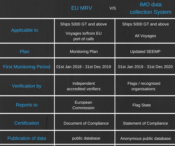
In fact barring few exemptions, both the regulations have same requirements.
There is one main difference between EU MRV and IMO regulation on data collection system.
The data published by the EU MRV will be distinct, meaning people can get the data for the each ship and company.
The data published by the IMO will be anonymous, meaning the people can see the data as per type of the ships etc but not for each ship or for a particular company.
Conclusion
EU MRV regulation is about measuring CO2 emission from the ships of more than 5000 GRT operating in EU ports.
Monitoring plan provides the information on how ships need to monitor the co2 levels.
This data once verified needs to be submitted to European Commission.
This regulation might turn out to be a game changer in reducing the CO2 emission from the ships even before it specifies the max CO2 emission level.
This is because of the every ship’s CO2 emission data that European Commission would publically upload.
The first step for the compliance with the EU MRV regulation is submitting the monitoring plan to the verifier. The last date for submission is 31st Aug 2017.
Here is the brief timeline for EU MRV regulation.
So if your ship is trading in European ports, is your ship ready with the EU MRV regulation?
Here is What You Need to Know about Enhanced Survey Programme

The way ships are maintained has changed since last decade or two.
Rarely will it happen that a seafarer completes his contract without the ship going through any survey or inspection.
It is now surveys and inspections all the way.
We have one or more surveys and inspections to cover each element of the ship.
For example, surveys for safety equipment certificate ensures that ship’s safety equipments are maintained in the way these should be.
Safety construction, load line certificate surveys deal with the construction part of the ship.
So where does “Enhanced survey programme” fit in all this and why do we have this?
To understand that let us briefly go to the history of the enhanced survey programme.
Why Enhanced Survey Programme?
The Enhanced survey programme is applicable for bulk carriers and oil tankers.
Definitely, IMO found something grossly wrong with these ships. Something so wrong that they had to bring more stringent regulation for these type of ships.
Here is what was wrong.
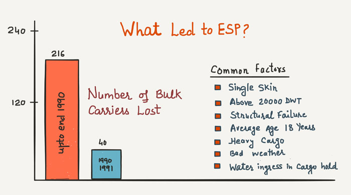
So many ships and lives lost !!! All because something was wrong with either the design of the ship or with the maintenance of the ship.
During this period, the number of oil tankers lost may not be as many as bulk carriers but oil tankers were included for the requirements of ESP because of cargo these carry.
Following these incidents, more and more P&I clubs started to question the quality of surveys done by the classification societies.
In 1993, IACS introduced Enhanced survey program for more close up inspections of these ships.
But then again In 1994 alone, 12 bulk carriers were lost in the sea.
This made the IMO to take special measures and to adopt a new SOLAS chapter (Chapter XI-1) to enhance maritime safety.
Among other requirements, this new chapter required bulk carriers and oil tankers to go through enhanced survey program.
What is Enhanced survey programme
A ship undergoes four type of surveys during its 5 yearly cycle of statutory surveys.
- Annual Survey
- Intermediate survey
- Renewal Survey
- Dry dock survey
So where does Enhanced survey programme fit in these?
Enhanced survey programme is not a separate survey. ESP just gives the specific guidelines about what to inspect during these surveys with respect to hull and structure of bulk carriers and oil tankers.
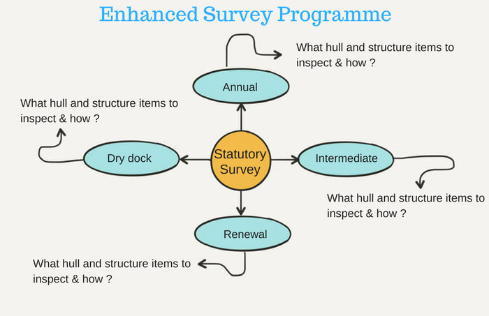
These detailed guidelines are given in the ESP code.
Let me give you a brief about these guidelines.
Who to inspect
- For bulk carriers of 20,000 tons deadweight and above, two surveyors should jointly carry out the first scheduled renewal survey after the bulk carrier passes 10 years of age (i.e. third renewal survey), and all subsequent renewal surveys and intermediate surveys.
- On bulk carriers of 100,000 tons deadweight and above, the intermediate survey between 10 and 15 years of age should be performed by two surveyors.
When to inspect
- The renewal survey may be commenced at the fourth annual survey and be progressed during the succeeding year with a view to completion by the fifth-anniversary date.
- A survey in dry-dock should be a part of the renewal survey. There should be a minimum of two inspections of the outside of the ship’s bottom during the five-year period of the certificate. In all cases, the maximum interval between bottom inspections should not exceed 36 months
How to inspect
- For ships of 15 years of age and over, inspection of the outside of the ship’s bottom should be carried out with the ship in dry-dock. For ships of less than 15 years of age, alternate inspections of the ship’s bottom not conducted in conjunction with the renewal survey may be carried out with the ship afloat.
- In any kind of survey, i.e. renewal, intermediate, annual or other surveys having the scope of the foregoing ones, thickness measurements of structures in areas where close-up surveys are required should be carried out simultaneously with close-up surveys
I have just given a couple of bullet points about what these guidelines are.
If you get your hands on ESP code, you will see that these guidelines provide much more details than this.
It covers the minimum requirements for the inspection of ship’s hull and structure during each type of survey. The structures like
- Cargo holds and hatch covers
- All pipings
- Ballast tanks
- All Hull plating
- Watertight bulkheads
It also guides about the extent the inspection (overall survey or close up survey) for each of these elements during these surveys.
The overall survey is intended to report the overall condition of the hull structure. For example, as per ESP code during the annual surveys, the overall survey of the cargo tanks need to be carried out.
This would mean that surveyor needs to do the good visual inspection of the cargo hold.
Close up survey is a survey where the details of structural components are within the close visual inspection range of the surveyor, i.e. normally within reach of hand.
Again as per ESP code, a Close-up survey of cargo holds is required during renewal survey. So during renewal survey, each part of cargo hold need to be in hand reach range of the surveyor.
So shipowner may need to arrange for scaffolding in the cargo holds.
Now that we know few things about ESP, let us understand the process involved in the ESP.
1. Survey Programme
ESP code requires that a survey programme is developed before the renewal survey.
The survey programme document gives the complete detail of what needs to be inspected and what resources are required to conduct the survey.
Survey programme gives the inspecting surveyor a written plan to follow.
Survey programme is sometimes also called “Survey planning document”.
The purpose of this planning document is to identify the hull related critical areas that must be inspected during the renewal survey of the ship.
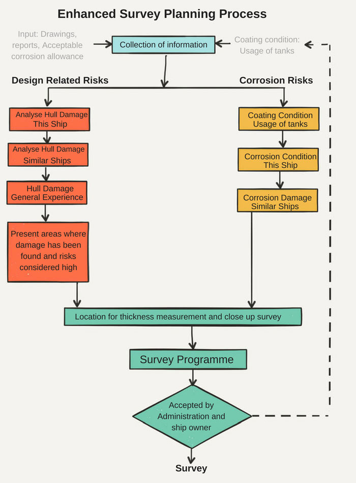
But how these critical areas are identified? These few resources help in identifying these critical areas.
i) ESP Code
ESP code has detailed instruction on the minimum criteria for inspection during each of the statutory survey.
For example, Annex 1 of the ESP code defines the requirements for the close-up survey during renewal survey of the ship.
Similarly, Annex 2 of the ESP code defines the requirements for the thickness measurement during renewal survey of the ship.
So the guidelines given in the ESP code becomes the first resource on the basis of what “Survey programme” or “Survey planning document” is developed.
ii) Survey planning Questionnaire
Before survey programme is developed, the ship owner is required to complete a survey planning questionnaire.
Ship owner is supposed to provide information on
- Any hull related deficiencies identified during PSC inspections of the ship
- Any hull related non-conformities issued during SMS audits
- Cargo carried history of the ship to get the information on how frequently corrosive cargoes are carried that has the potential to damage the coating.
- The condition of the coating as per the ship owners inspection of the ship spaces.
The ship owner’s response on this questionnaire is considered while developing the survey programme for the ship.
For example, if in the survey planning questionnaire it is noted that cargo hold #1 has carried high sulphur coal very frequently, this hold may be subjected to more strict inspection.
In this case, survey programme would include more areas for a close-up inspection and thickness measurement of cargo hold # 1, above the minimum requirements of ESP code.
iii) Damage history
There is this one last information that is taken into account while developing the survey programme for the ship.
This is damage history.
Not only for the ship in question but also for the sister ships.
If the ship or its sister ships have suffered frequent damage of one particular area, that area is identified for more close up inspection during the renewal survey.
iv) General damage trends in the industry
Survey programme also takes into account general ship damage trends in the industry.
For example, let us say in short span of time a number of bulk carriers have sunk because of cracks at the midship area.
The more close up inspection and thickness measurement (over and above the minimum requirements as per ESP code) will be included in the survey programme.
v) Critical areas and suspect areas
Survey programme takes into account any critical areas and suspect areas. These areas are identified from the previous inspections or previous thickness measurement reports.
For example during previous renewal survey, if certain areas are identified as having substantial corrosion, these areas will be considered as suspect areas.
Once all the data is available, a specific survey programme is developed for the ship.
2. Survey planning meeting
Once survey programme is established, it is time for executing the survey programme.
Survey planning meeting is the first step in executing the survey programme.
Survey planning meeting is held before the renewal or intermediate survey is commenced. As the renewal survey is carried out during dry docking of the ship, this meeting will be carried out just before the dry dock.
This meeting is between the attending class surveyors, ship owners, and master/chief engineer of the ship and thickness measurement company.
The main agenda of this meeting is to discuss the
- Schedule of the ship
- execution of thickness measurement, such as when the holds/tanks will be ready for thickness measurement.
- the extent of close up survey
In short, the content of the survey programme becomes the agenda for discussion in the survey planning meeting.
3. Conducting the survey
After the survey planning meeting, the survey is carried out as agreed and as per survey programme and minutes of survey planning meeting.
Thickness measurement company will carry out the thickness measurement of the agreed areas.
The person carrying out the thickness measurement will usually highlight any structure related concern he finds while carrying the UT gauging to the class surveyor and the ship owner’s representative (usually superintendent).
Based on this, the class surveyor may extend the scope of thickness measurement.
4. Survey Reporting
Once the survey is complete, it is time for creating the report for the survey that will show the summary of all the surveys done and its outcome.
The reports that need to be generated are
Condition evaluation report
As the name suggests, this report gives the complete report of the renewal survey conducted for the ship.
For example, it would give the actual condition of the tank coating.
As per the ESP code, the condition of the tank coating need to be defined as any one of these
- Good
- Fair
- Poor
If a condition of class is issued to the ship as a result of renewal survey, the details of the condition of class will also be provided in the condition evaluation report.
Condition evaluation report would also have the details of any memorandum of class issued to the ship.
Condition evaluation report also documents and highlights any area that has been observed to have “substantial corrosion”.
Thickness measurement report
Condition evaluation report will provide the summary of thickness gauging report and any area of concerns identified in thickness measurement.
But we also need to have the complete thickness measurement report with all the measured readings of the hull structure and tanks.
This thickness report is required to be sent to the flag state.
What ship staff need to know about ESP
And now the most important question. What exactly ship staff need to know about ESP?
First, ship staff needs to know what all inspections and surveys are required to be done as per ESP.
This we already discussed so far in this post.
But the most importantly, ships staff need to maintain an ESP file on board.
This file will have
- Survey reports related to hull structures
- Condition evaluation report
- Thickness measurement report
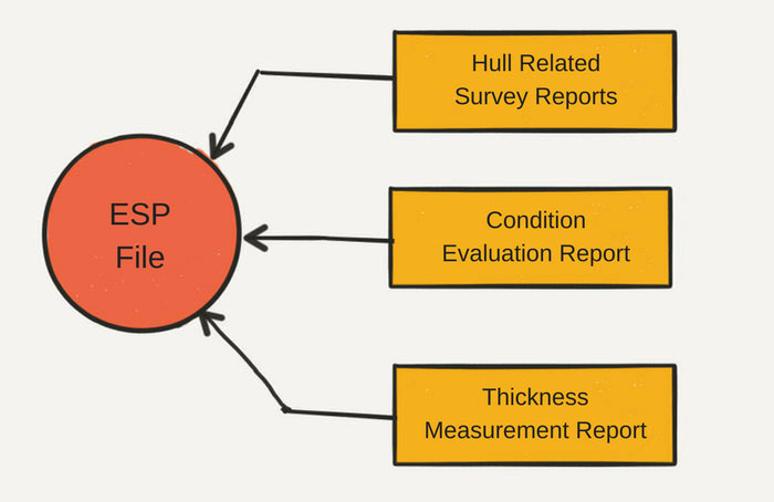
Master has to make sure that these records are available in the ESP file.
After the renewal survey, it takes some time for ship’s classification society to prepare condition evaluation report.
So condition evaluation report may arrive on board after one month from the completion of renewal survey.
During any inspections, the master must be able to convey this fact to the inspectors who may want to have a look at the condition evaluation report.
Same may be the case with thickness measurement report.
Master and the chief officer must understand the content of “condition evaluation report”.
They must know if any areas with “substantial corrosion” are identified in the condition evaluation report.
Also, they must know if any tank coating has been graded as “Fair” or “poor”.
Whenever ship staff is making the routine inspection of these sections of hull structure, particular attention must then be given to the areas identified to have substantial corrosion or with tank coating as “Fair” and “poor”.
Conclusion
The voyage of a ship is called an adventure because it is a risky environment.
These risks are found to be even higher for the Bulk carriers and tankers.
These risks increase many fold if the hull and structures of these ships are not maintained absolutely good condition.
Enhanced survey programme gives the specific guidelines for the inspection of hull related items during statutory surveys.
ESP has ensured these ships are maintained in a way that ensures the safety of the bulk carriers and tankers.